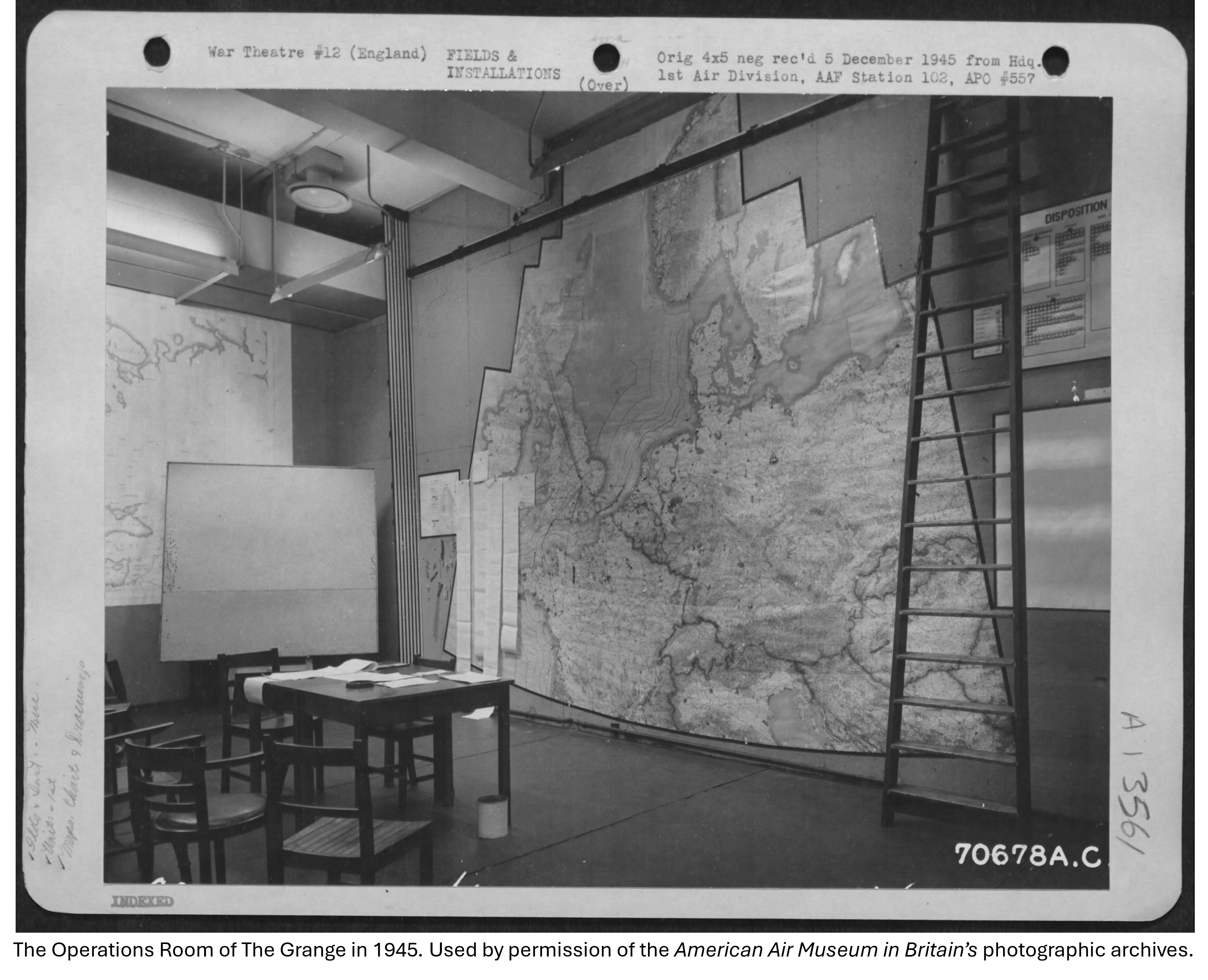
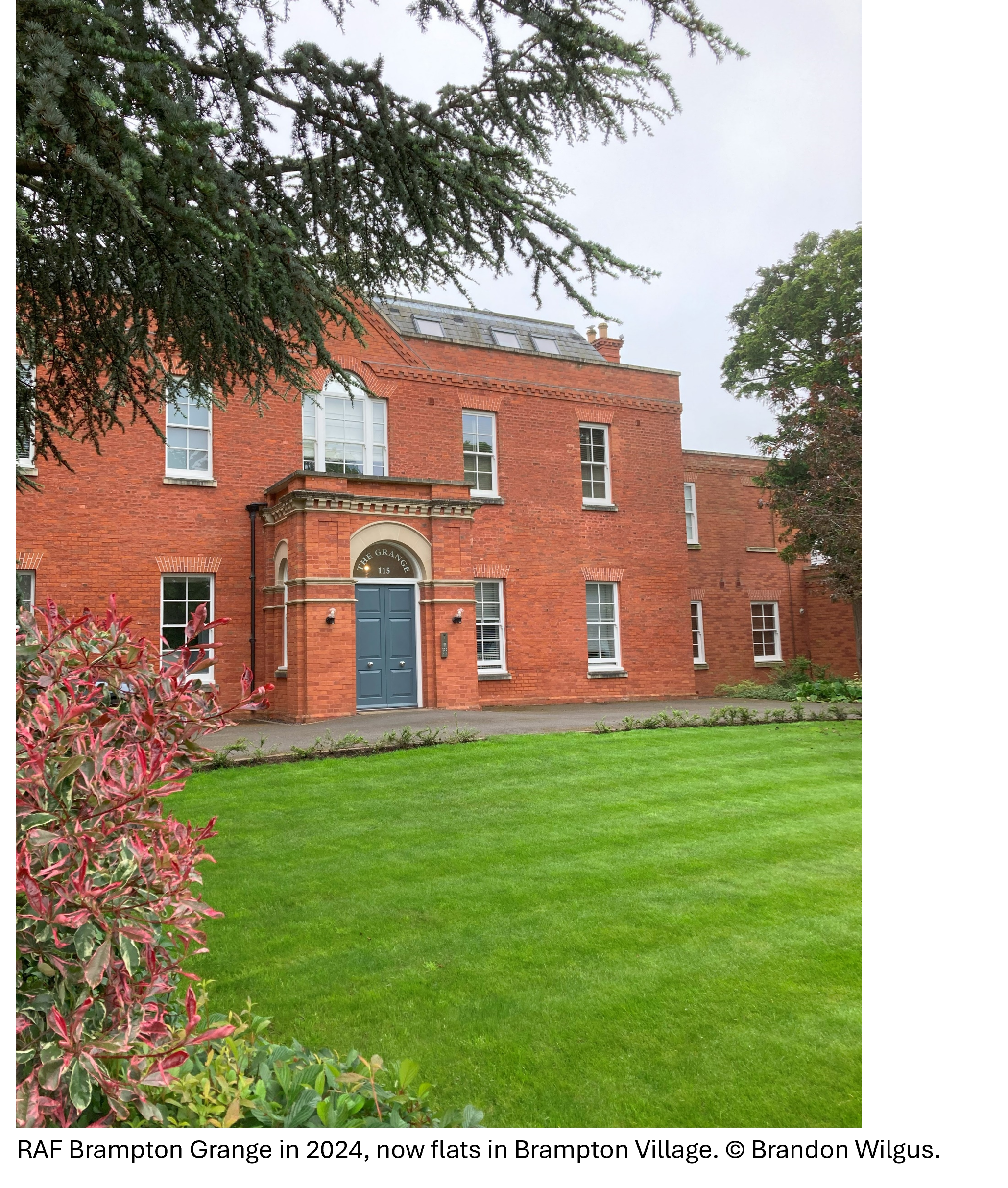
In the village of Brampton, Cambridgeshire lies a large, Georgian house built in 1773 called The Grange. Despite its early use as a girl’s school in the 19th Century and its connections with Lady Olivia Sparrow, the philanthropist and early evangelist, it is the Grange’s use in the Second World War as the headquarters of the 8th Air Force’s 1st Air Division that most interests me.
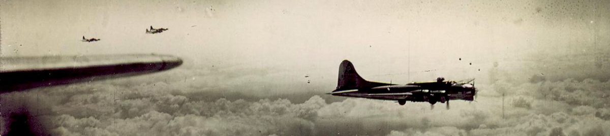
Several years into the Second World War, the United States was attacked at Pearl Harbor and was quickly at war with the Axis Powers. Settling on a Europe First policy, the US Army Air Corps immediately began moving heavy bombers to England, primarily the Boeing B-17 Flying Fortress and Consolidated B-24 Liberator, 4-engine bombers. In coordination with RAF Bomber Command, it was decided that the RAF would focus on night bombing missions while the US Army Air Corps would focus on high-altitude, precision daylight bombing. As forces and capacity grew, the goal was to move the combined British and United States strategic bombing campaign against Germany and occupied Europe into round-the-clock operations. This obviously would require an enormous amount of planning, plus operational command and control to be effective, and that is where The Grange in Brampton played its part in World War II.
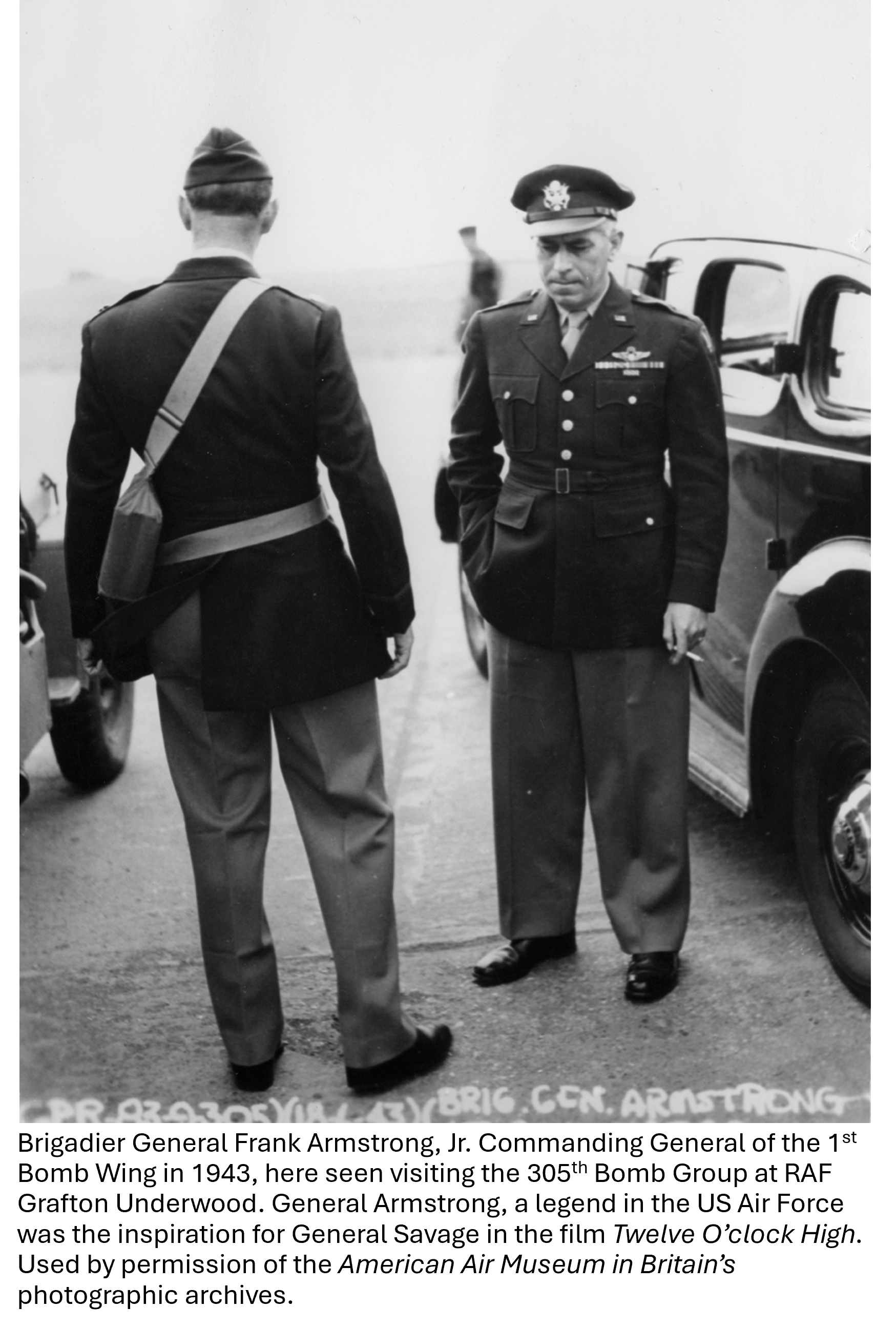
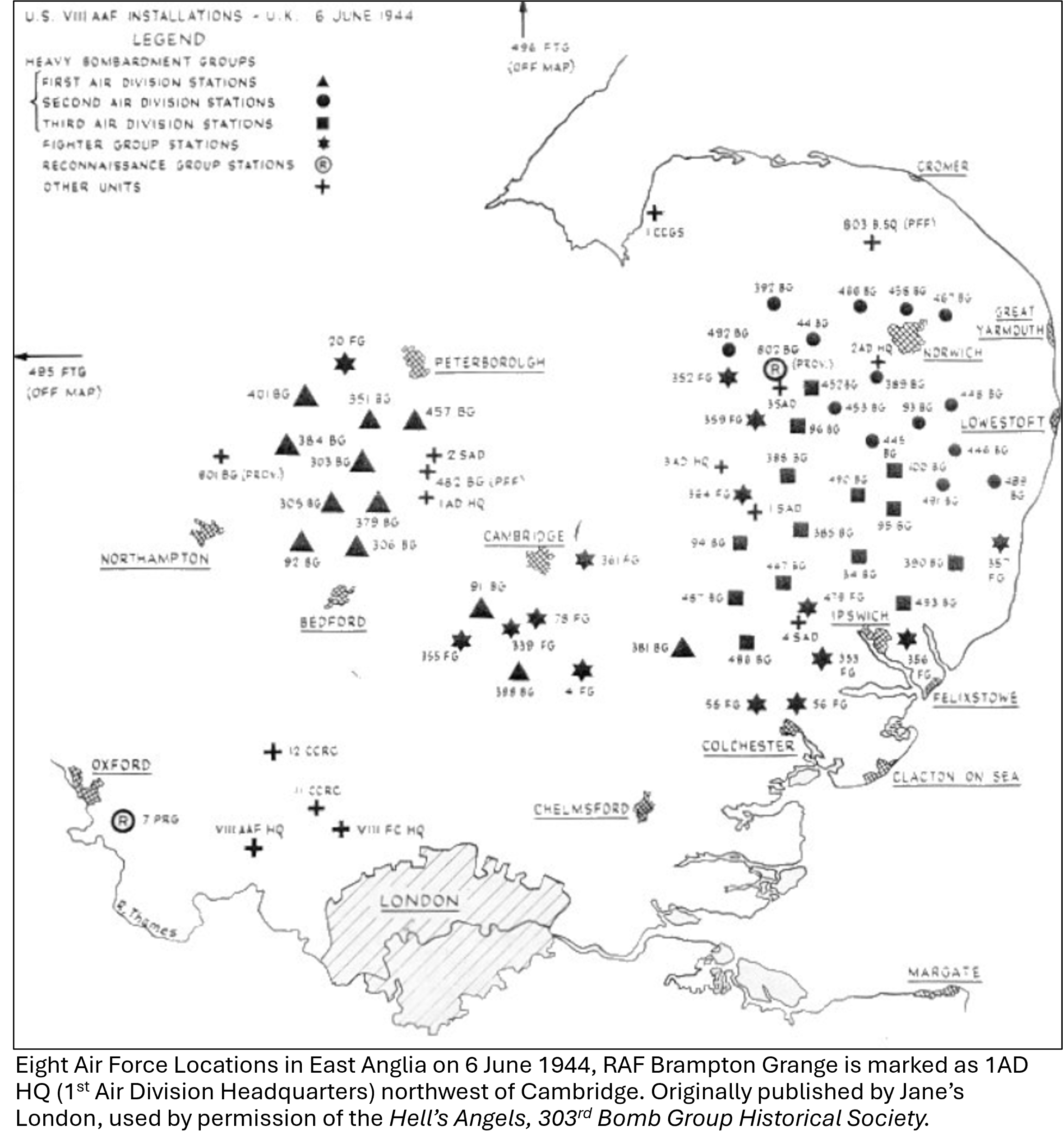
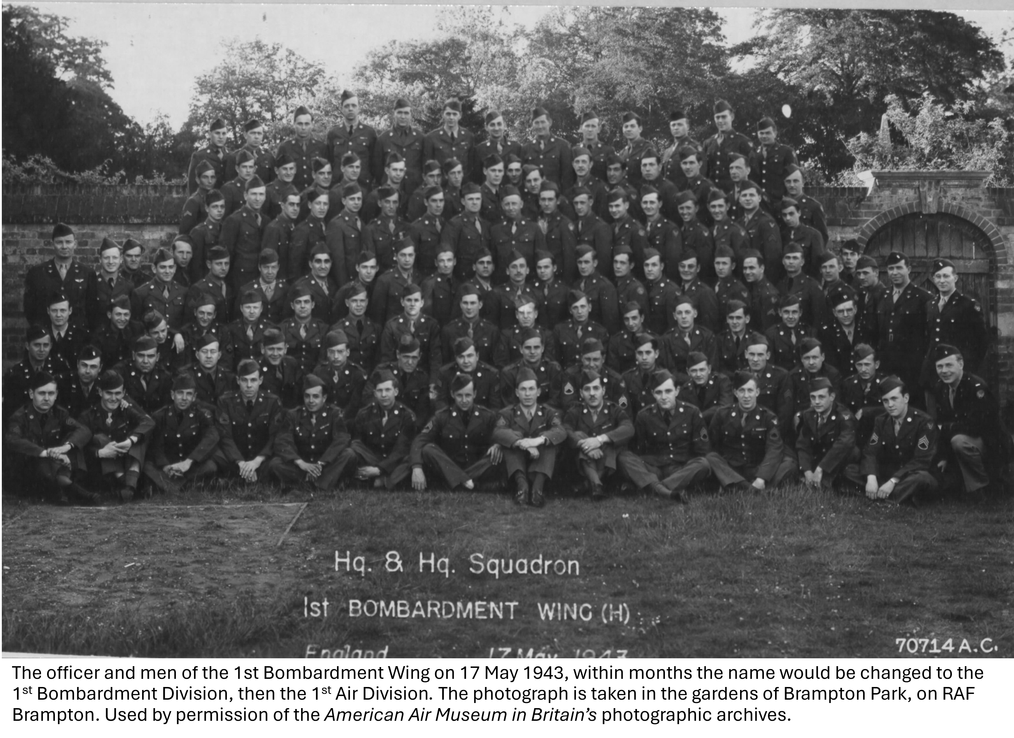
The US Army Air Forces in World War Two were organized under a Numbered Air Force (Lieutenant General, three-star Commander), then a Division (Brigadier General or Major General, one to two-star Commander), then a group (Colonel Commanding), and then squadrons (Major Commanding). More specifically, the US Bombers in England were organized under the 8th Air Force at RAF Daws Hill located near Bomber Command at RAF High Wycombe. 8th Air Force was divided into three Divisions and the First Bomber Division was headquartered at the Grange in Brampton, referred to as RAF Brampton Grange in official documents beginning in 1943.
Almost all the bomber and fighter groups and squadrons in Cambridgeshire were commanded by the First Bomber Wing in Brampton, renamed the First Bomber Division, and finally renamed in 1944 the First Air Division. By the war’s end, the 8th Air Force was spread over 112 airfields across East Anglia, flying B-17 and B-24 heavy bombers, B-26 Marauder medium bombers, P-38 Lightning, P-47 Thunderbolt, and P-51 Mustang fighters, as well as Spitfires and Mosquito bombers provided by the RAF. Throughout the war, the 8th Air Force dropped 700,000 tons of bombs on Germany and occupied Europe, flew 600,000 bomber and fighter sorties, and destroyed over 15,000 enemy aircraft by air-to-air engagements, ground strafing, or by bomber crew engagement. 35,000 men and women would serve with the 8th Air Force during the war, with many thousands never returning home. Much of that enormous effort was planned and executed from the Grange in Brampton.
At the war’s end, the headquarters and staff were moved on 25 April 1945 from The Grange in Brampton to RAF Alconbury, a few miles away, where the US Air Force still operates a wing commanding several bases and facilities today. After 1945, The Grange operated as the RAF’s Technical Training Command, responsible for organizing aircraft maintenance and aircrew training. Then in 1980, released from the RAF, it became a restaurant and hotel in the village of Brampton for many years, before being converted into flats in 2013.
Today, with no historical marker or blue disc to identify it, most people are unaware of the remarkable wartime history of The Grange in Brampton. However, it is certainly worth a visit along the Brampton High Street new Huntingdon in Cambridgeshire.
Located between Huntingdon, Godmanchester, and Brampton Village is a low-lying meadow along the River Great Ouse. Having existed as a protected place since medieval times and known as the largest meadow in England, Portholme Meadow is treasure. The site was historically dubbed Cromwell’s Acres due to his connection with the area and the nearby presence of Hinchingbrooke House but it is Portholme Meadow’s early connections with aviation in Cambridgeshire that I want to explore. While the meadow is a wildlife paradise, a Site of Special Scientific Interest, and an important part of managing flooding in the area during the winter, it is its aviation history that is an almost forgotten story and a key piece of Cambridge military history. At 104 hectares, wholly located in the Brampton Parish, the Portholme Meadow was used as a Royal Flying Corps and RAF training area during the later part of the Great War and beyond, but its connection with aviation began earlier.
In 1910, just two years after Samuel F. Cody had flown the first aeroplane in England, James Radley, an early aviation pioneer based in Bedford believed that the flat areas of the Portholme Meadow, shielded from winds, and accessible to local towns, were ideal for take-off and landing as well as demonstrating to an enthused public the wonder of flight. Having acquired a Beleriot monoplane (the French aviator had recently flown the channel and the Alps), on 19 April 1910, with almost the whole population of Huntingdon, Godmanchester, and Brampton watching, Radley took off and flew circuits of the meadow to the amazement of the local crowds.
While several flights were made, Radley’s aircraft was able to complete a 16.5 mile circuit of the meadow at an altitude of 40 feet in just under 24 minutes – just over 41 miles per hour.
After this success, a workshop was aquired in Huntingdon, on St. Johns street, and James began to assemble his aircraft along with his partner Will Morehouse. Their company, Portholme Aerodrome Ltd. was founded and the first locally produced aeroplane was flown on 27 July 1911 from the meadow.
Despite local enthusiasm, Radley and Moorehouse’s business venture was not a succes. Their debts mounted and they were unable to produce a commercially viable aircraft. In 1912, they sold Portholme Aerodrome Ltd. to Handly Page which also struggled to maintain profitable aircraft production in Huntingdon. However, flying did continue in Portholme Meadow up until the Great War, largely for practice and demonstrations for the public. When the Great War began, the admiralty awarded Handly Page a license to produce 20 Wight Seaplanes for the Royal Navy, but this contract was canceled in 1916 after only four aeroplanes were produced due to issues with the construction. Consummed with debt and the war over, Portholme Aerodrome Ltd. went into receivership in July 1922.
However, it was later in the Great War that the Royal Flying Corps, which became the RAF in April 1918, used the meadow for flight training, and this use would continue into the 1930s. At one point, the Portholme Meadow was considered for conversion into an airfield, but luckily this never occurred, and this beautiful and unique piece of nature was conserved. As aircraft became larger and maintenance requirements grew, the RAF moved the remaining aircraft from the grassy meadow to RAF Digby in Lincolnshire and Portholme Meadow’s brief history with aviation came to an end.
If you would like to visit Portholme Meadow, it can be accessed from Godmanchester, Huntingdon, or Brampton but I would recommend parking at The Brampton Mill, Bromholme Lane, Huntingdon, Cambs. PE28 4NE, where the Meadow can be accessed by public footpath – and an excellent lunch or pint can be had after your visit.
Sources:
Doody, J.P., Portholme Meadow: A Celebration of Huntingdonshire’s Grassland. The Huntingdonshire Fauna and Flora Society, 60th Anniversary Report, eds., H.R. Arnold, B.P. Dickerson, K.L. Drew and P.E.G. Walker. 2008.
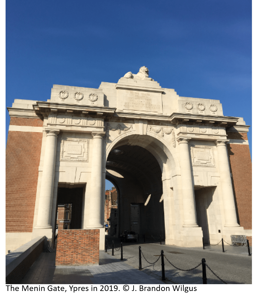
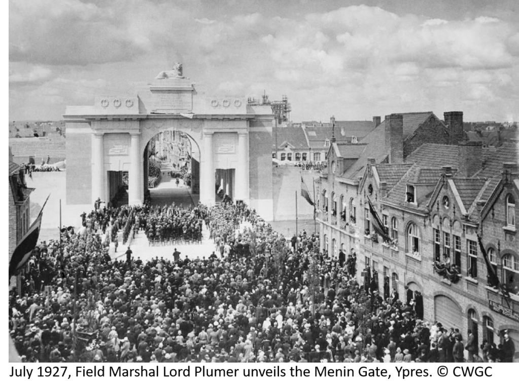
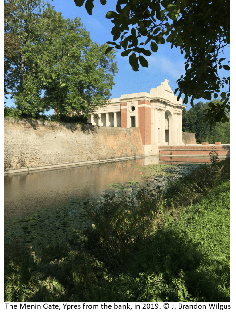
It is a somber place, the Ypres Salient, where so many young men perished between 1914 and 1918. I have begun a series of hikes around the many battlefields, following Paul Reed’s excellent guide: “Walking Ypres”. However, my exploration of the Ypres Salient rightly begins at the Menin Gate, a memorial to the British and Commonwealth soldiers missing from the beginning of the war until 15 August 1917. It was then that 55,000 names of missing men had been reached and additional names would be recorded on other memorials around the Salient. However, for the missing from Commonwealth countries: Australia, Canada, and South Africa, all their missing from the Ypres Salient are recorded at the Menin Gate. The memorial was built in the 1920s and unveiled in July of 1927. At the unveiling of the monument, Field Marshal Herbert Plumer, 1st Viscount Plumer, who had led forces in the Salient during the war, most notably at Messines Ridge, famously said of those with no graves: “They are not missing, they are here.”
Originally, the gate was an opening in the 17th Century walls built by Vauban which led from the medieval market town of Ypres to the town of Menin some miles away to the east. During the war, the opening in the walls led to the front, and as the war progressed, hundreds of thousands of men would pass from the town through the destroyed portal to the trenches and dugouts which surrounded the tenuous British position in the salient. Ypres itself came under increased German shelling throughout the war and was almost completely destroyed by the armistice in 1918. Soldiers passing from Ypres through the ruined walls to the trenches were said to joke: “tell the last man through to bolt the Menin Gate.”
Beginning in July 1928, only interrupted during the German occupation during the Second World War, the Last Post Buglers’ Association has played the Last Post at 8 pm each evening under the arch of the Menin Gate. In fact, as Ypres was liberated by Polish forces in the Second World War, the ceremony was bravely resumed by local firefighters while fighting continued in the town. It is a moving ceremony and a credit to the Belgian allies of Great Britain, the citizens of Ypres, who have maintained this somber tradition for almost a hundred years. Each night, traffic is stopped and visitors stand silently as the buglers play in unison the Last Post, which echoes under the gate and among the 55,000 names of the missing. It is fitting to feel overcome by a sense of loss and tragedy at such a moment.
An amazing thing recently happened. A friend of mine, stationed at RAF Molesworth, the old airbase of the 303rd Bomb Group (H) in the western part of Cambridgeshire, came by my office. He brought me a box of old photographs – all photos from airmen and officers of the 303rd, part of U.S. 8th Air Force, taken during the Second World War at RAF Molesworth. He asked if I wanted them. Of course! I was amazed. They are wonderful historical records. On top of the stack of photos – there must be 70 – there was a handwritten note, which read: “Dupes of WWII photos donated by Malcolm Magid, plus copies from old JAC XO, CAPT Mewbourne.” This note tells me quite a few things, namely the photos were in the possession of the Joint Analysis Centre (JAC) Executive Officer (XO), who was a naval officer (the acronym CAPT is only used for a U.S. Navy Captain, the other branches of the U.S. military use different acronyms: Capt., CPT, or Capt). The JAC command has only been at Molesworth since 1990 – so that gives some idea of the timeline of the photos ownership.
More importantly, Mr. Malcolm James Magid was a B-17 co-pilot who survived the war and passed away in Atlanta, Georgia on 16 May 2012 at the age of 88. He was stationed at RAF Molesworth and flew 35 missions over Germany during the War. He was highly decorated, even being made a Chevalier of the Légion d’honneur by the President of France for his aid in the Republic’s liberation.
2LT Malcolm Magid Service Photo, thanks to the 303rd BG(H) Historical Society
For the photos themselves, I asked myself what to do? First, I thought I will scan them in and post them here as a record of the brave men who served at RAF Molesworth, and in honour of Mr. Magid. Secondly, I will attempt to find Mr. Magid’s family (an obituary published in a local paper lists his descendants) and see if they would like these photos returned. If that effort is unsuccessful, I will contact the U.S. Air Force Historical Society and the 303rd Bomb Group Historical Society to see if the photos can be added to their collections. More to follow.
For now, please enjoy these photographs. I think you may feel as I do that these men are all so very young…
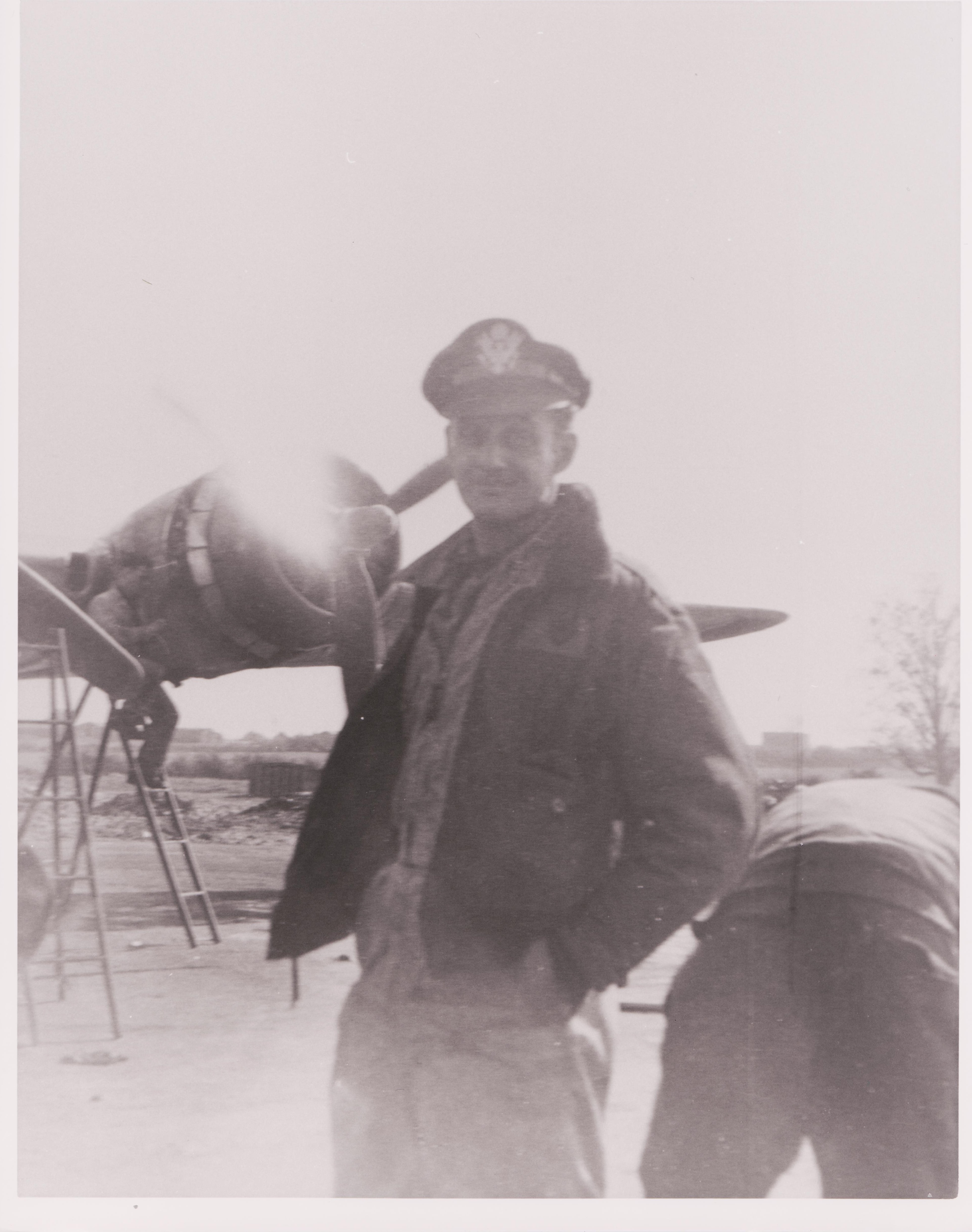
This appears to be 2LT Malcolm Magid standing infront of a B-17 undergoing maintenance.
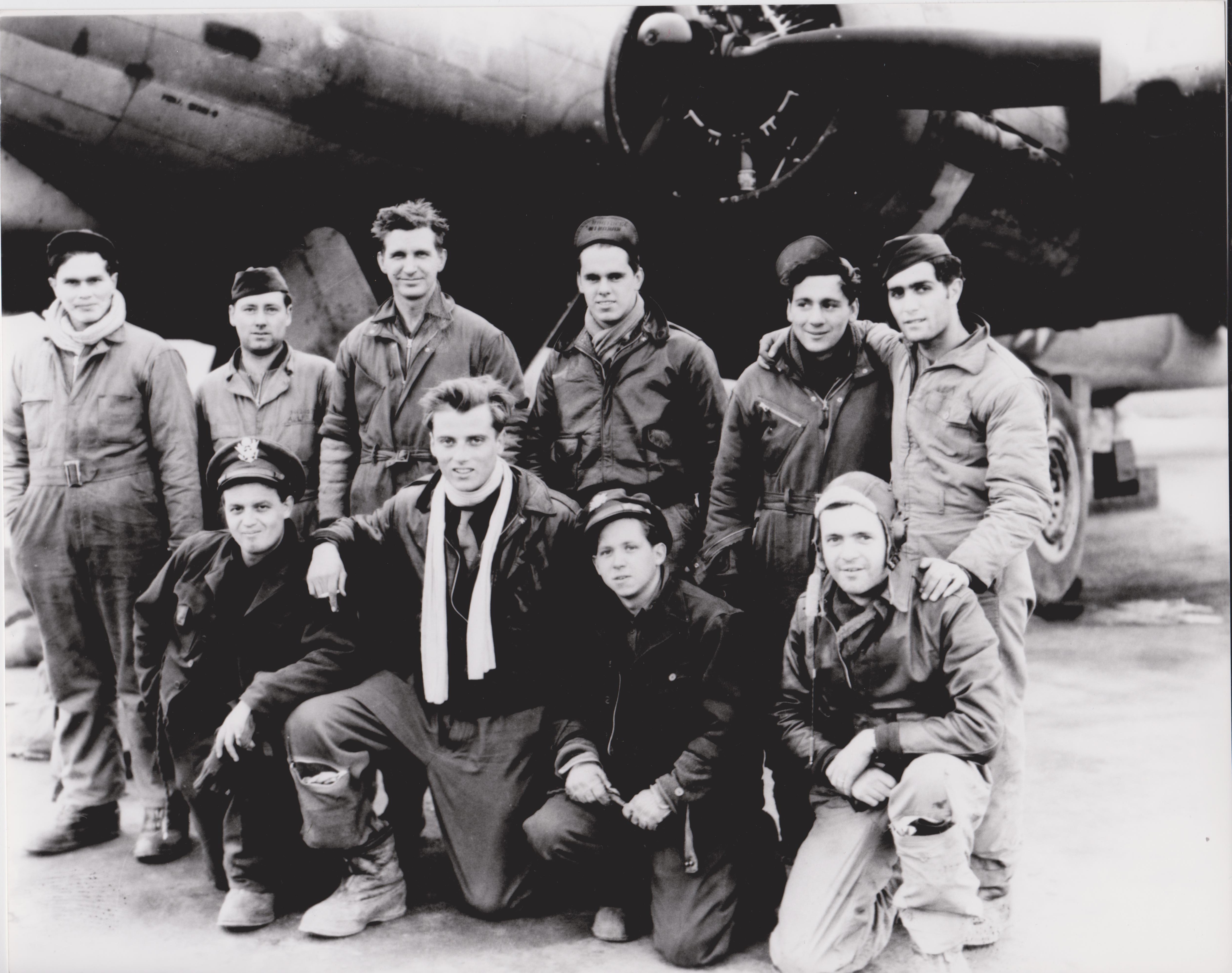
B-17 Crew in front of aircraft. I am (moderately) confident that 2LT Magid is kneeling in the front row on the far left, wearing the peaked cap. The officer in the front row, third from left, is striking in how young he looks.
B-17 Cockpit.
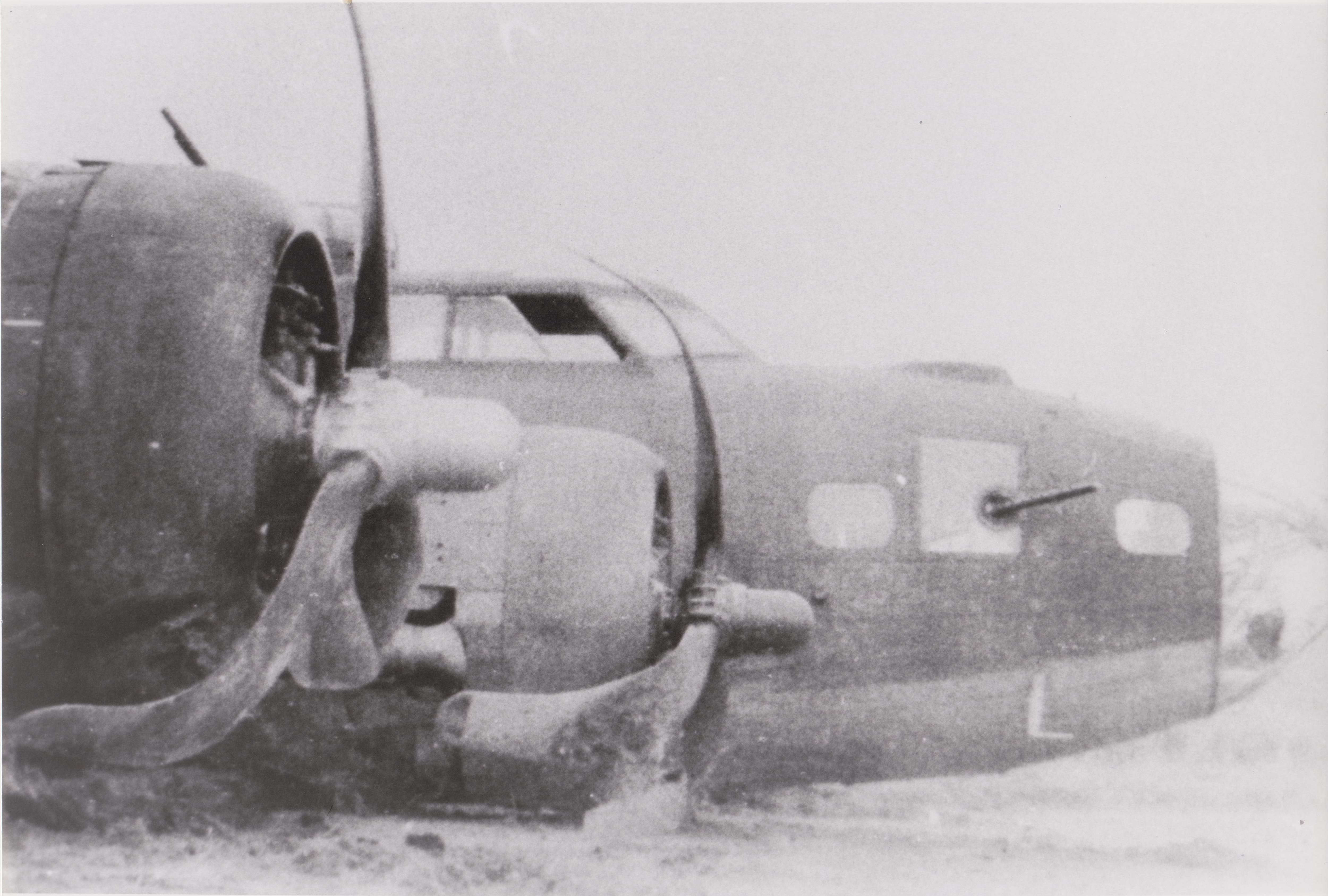
Photo of a B-17 after making a wheels-up landing (the aircraft is in remarkable shape).
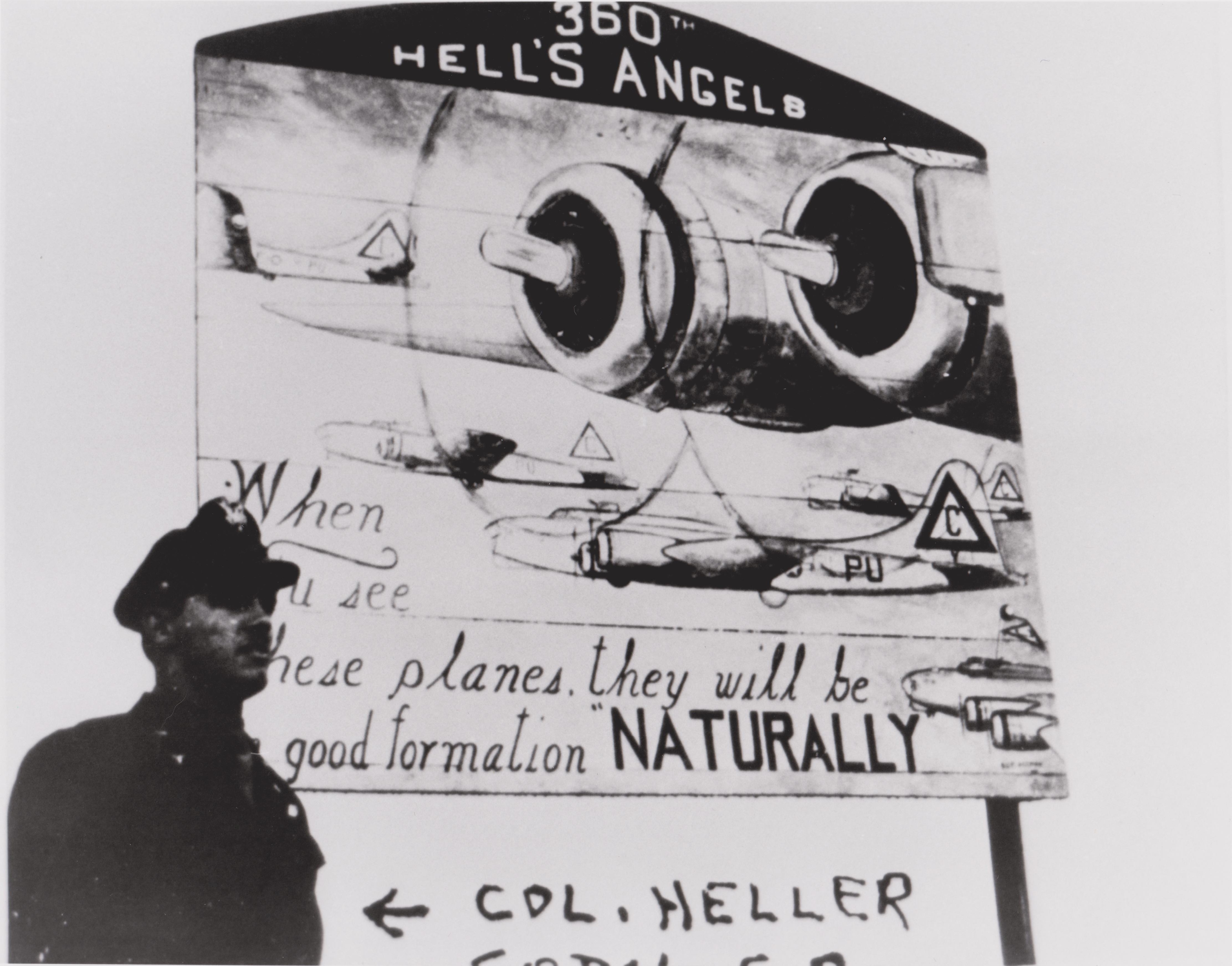
Written on the negative is “COL. Heller… [illegible]” Colonel Heller was the 360th Squadron Commanding Officer, a subordinate unit to the 303rd Bomb Group (H).
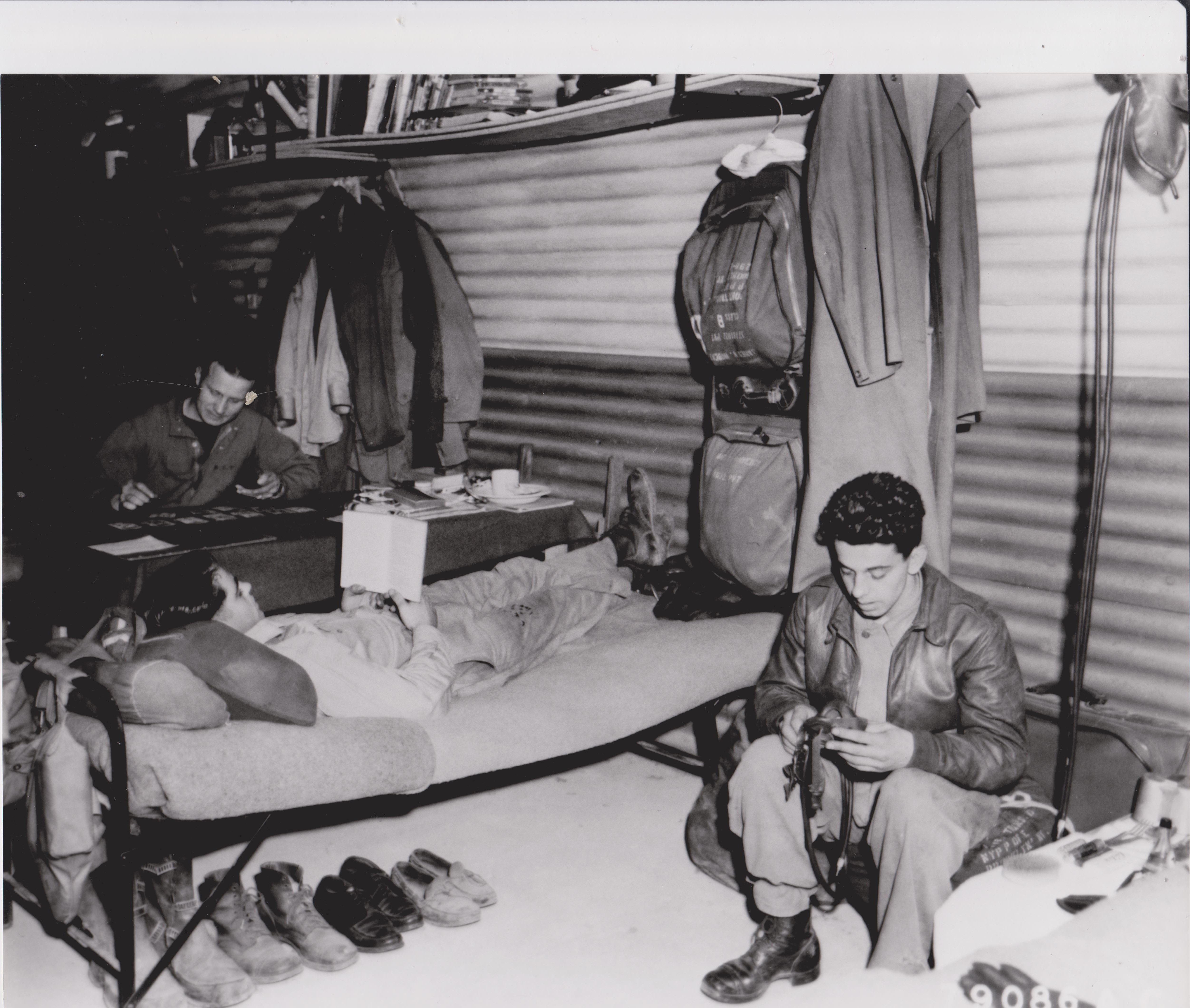
Inside a Nissen Hut. Of note: under the cot are flying boots, uniform dress shoes, and tasselled loafers. The airman in the background is playing solitaire.
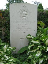
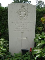
During the night of 27 April 1944 a de Havilland Mosquito night attack fighter from 613 Squadron was airborne for a raid on the German fighter airfield at Vliegbasis Twenthe (Dutch: Twente Airbase) in the eastern border area of the Netherlands. The Mosquito was on an intruder mission, a low-altitude strafing/bombing run on a fighter base in the darkness. Coming in low and from the east the Mosquito was only two kilometres from the Luftwaffe base when (according to local accounts) search lights were switched on and anti-aircraft fire began, blinding Flight Sergeant R. J. E. Adey and his co-pilot K. J. Pinnell, who were brought down into the trees in the Haagse Bos (Dutch: Haagse Woods), both men dying during the crash.
DeHavilland Mosquito FB.VI of RAF 613 Squadron at RAF Lasham, June 1944. This photo was taken two months after the crash in the Haagse Bos. Notice the Recognition or “D-Day” stripes on the aircraft. By Ringwayobserver – Licensed under CC BY-SA 3.0 on Wikimedia commons.
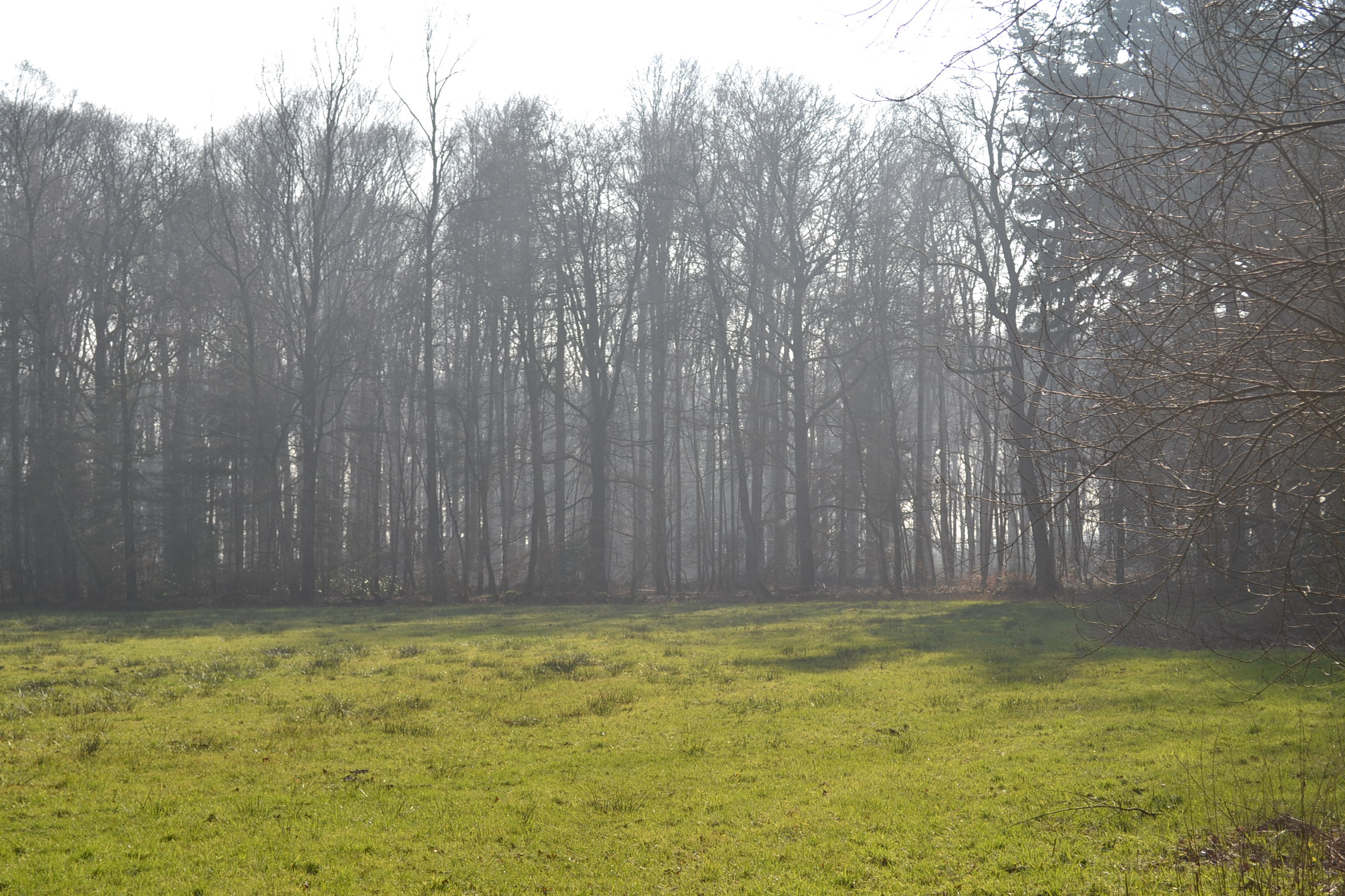
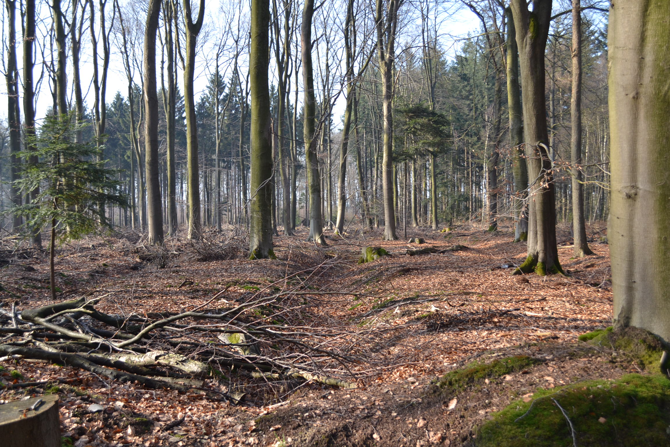
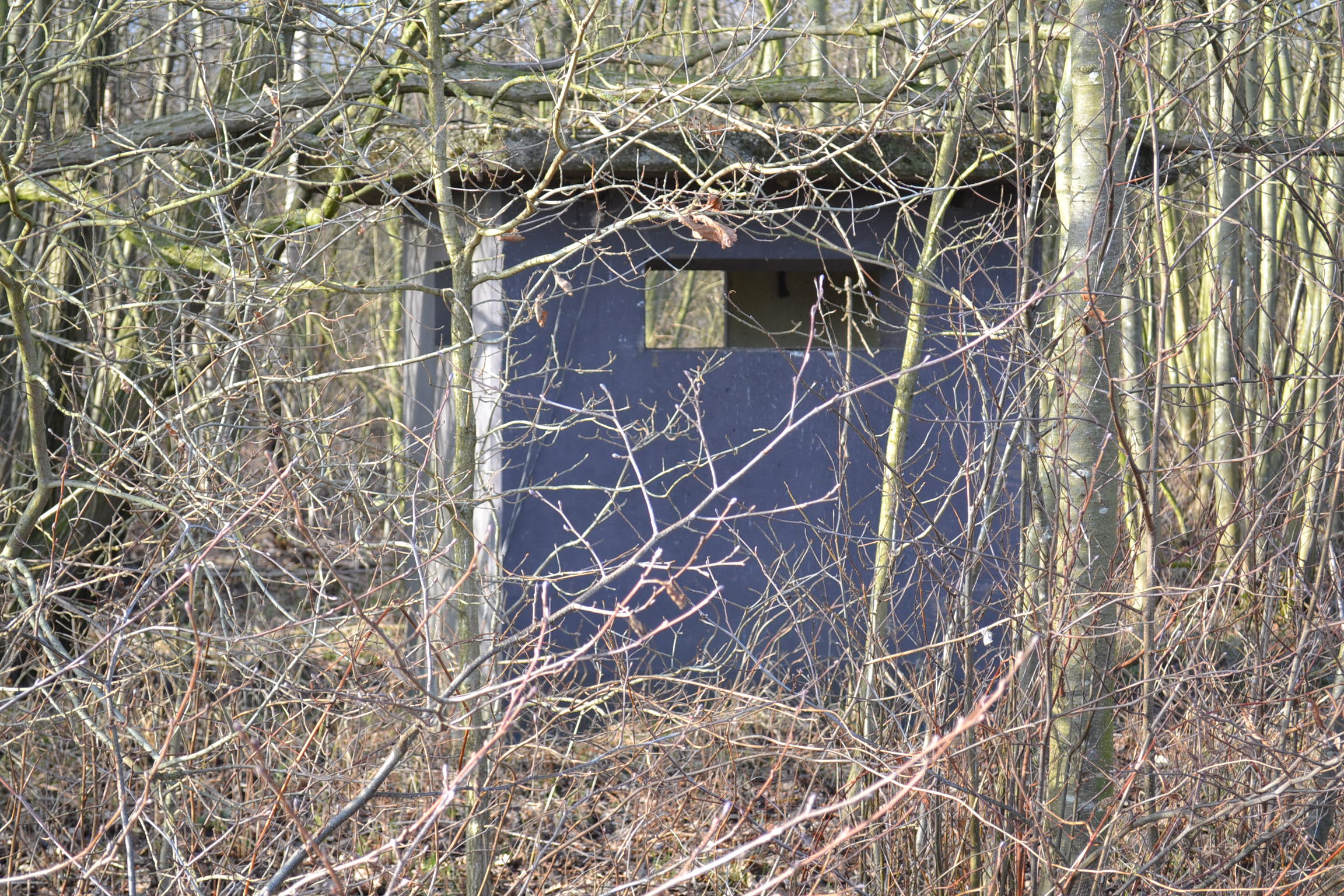
This area, the Haagse Bos, happens to lie near my in-laws home in Enschede, the Netherlands, and as the years have passed, I have often found myself hiking in the woods. A small wooden marker on the path, near the forest where the Mosquito crashed on 27 April 1994 is there to remind us of the sacrifice by these two men on a night-time raid in a almost completely wooden, high speed, light bomber. I felt compelled to learn more about the crash. I wanted to find the spot where the plane went down, aware that very little of the aircraft would remain, since the de Havilland Mosquito was designed for speed and was mostly a wooden construction bomber built around a metal frame.
I’ve oriented the below photographs onto the aerial photo from the late 1940s mentioned. #3 is the location of the Mosquito crash site. The photograph is oriented with North at the top of the photo, the Vliegbasis Twenthe is 2 km WSW of the crash site.
Aircraft archaeology efforts paid off quickly, as the sacrifice of the two British fliers who crashed here in 1944 were quietly honoured at the time and have been respectfully remembered by the citizens of the Dutch city of Enschede since. An aerial photograph from the late 1940s identified the crash site, approximately 150 meters from a small wooden marker that records the crash. From there, using the overhead photo and a picture from the 1980s which shows scarring in the trees from the Mosquitoes’ crash, I could vector in on the site. It was during these exploratory efforts that we discovered a fresh bouquet of flowers last April, on a cold afternoon, lying next to the wooden marker near the site. The flowers were a moving, quiet act of gratitude to the two men who flew the aircraft from an anonymous person, left 71 years after their death.
This aerial photograph shows the area from above, taken in the late 1940s, and is the one which allowed me to locate the site. At the time, the scaring in the trees from the Mosquito’s impact and fire was still visible. (Remarkably, in the early 1980s, scarring in the trees was also mentioned in a local Dutch newspaper with an accompanying photograph, but by 2015 to 2016 I could not discern any noticeable change, most likely since some timbering took place in the area after the 1980s story). The photos I’ve taken with my camera are numbered, with the number corresponding to a place on the aerial picture where I stood taking the photo. The v-shaped arrow shows the direction of the photograph, to help orient the ground images to the overhead photo. The location of the plane’s final position is a close approximation, since debris was likely spread as the plane hit the trees at high speed, but this final photo is the location of the wreck and visible damage to the woods from 70 years ago.
A few kilometres east of the crash site is VliegbasisTwenthe, which the Royal Netherlands Air Force maintains as a fighter divert airfield. During the Second World War, the Luftwaffe used the airfield as a Messerschmitt BF 109 fighter airfield: the target of the Mosquito’s low altitude night-time raid. Maintained and used by the Dutch Air Force since World War II, there are several anti-aircraft hardstands, pill boxes, and firing positions from the time it was used by the Luftwaffe which still survive.
After the plane crashed, locals removed their bodies which were later identified and interred in a local cemetery. Flight Sergeant Royston John Edward Adey was 21 years old at the time of his death. His parents were Ronald John Edward Adey and Edith Rose Mary Adey, still living in their family home, Winshill, Burton-on-Trent in Staffordshire. In St. Mark’s Parish Church in Winshill there are two boards marking the names of men from the village who fell in the First and Second World Wars, Flight Sergeant Adey’s name is memorialized there. His final resting place lies under a Commonwealth War Graves Commission marker in the Oosterbegraafplaats Enschede, the Netherlands.
Flight Sergeant Kenneth John Pinnnell was 22 years old at the time of his death. His parents, Daniel John Pinnell and Mary Pinnell survived him. Flight Sergeant Pinnell was from Coventry. His grave is also in the Oosterbegraafplaats Enschede cemetery, the Netherlands. He and Flight Sergeant Adey rest a few meters away from one another. Quietly, restfully, these two brave aviators lie in a small corner of a foreign field and I’m reminded of the poet Rupert Brooke, who died on a hospital ship in the Mediterranean in 1915 wrote:
If I should die, think only this of me:
That there’s some corner of a foreign field
That is for ever England. There shall be
In that rich earth a richer dust concealed;
A dust whom England bore, shaped, made aware,
Gave, once, her flowers to love, her ways to roam,
A body of England’s, breathing English air,
Washed by the rivers, blest by suns of home.
And think, this heart, all evil shed away,
A pulse in the eternal mind, no less
Gives somewhere back the thoughts by England given;
Her sights and sounds; dreams happy as her day;
And laughter, learnt of friends; and gentleness,
In hearts at peace, under an English heaven.
One of the interesting things about living in Cambridgeshire is seeing the uniforms of U.S. servicemen and women stationed here in England. Many of these men and women serve in the U.S. Air Force, on Royal Air Force Bases, across East Anglia and the East of England. However, it wasn’t too many decades past when U.S. Army and Navy personnel were commonly seen in England as well, especially during the Second World War. Even before the attack on Pearl Harbor and the United States entering the war in December 1941, there were high-level contacts at the General Staff level between the United States and United Kingdom. In fact, as early as March 1941, the United States, United Kingdom and Canada had agreed on: “The early defeat of Germany as the predominant member of the Axis with the principal military effort of the United States being exerted in the Atlantic and European area; and a strategic defensive in the Far East.” – this was the Europe First policy which was the basis of the Allied war effort throughout the Second World War. So when the attack on Pearl Harbor came and the United States found itself at war with the Axis Powers: Germany, Japan, and Italy, it was only a short amount of time before U.S. Army and U.S. Army Air Corps (the forerunner of the U.S. Air Force) personnel began arriving in droves across England.
It was on January 26, 1942 that the first U.S. combat troops arrived in England. As U.S. forces arrived in England, they were handed a publication titled: “Instructions for American Servicemen in Britain”. Along with all sorts of useful advice to help with the large influx of Americans, servicemen were told never to insult the monarchy, and that “the British don’t know how to make a good cup of coffee, but you don’t know how to make a good cup of tea. It’s an even swap.” It is important to note that individual Americans were serving with UK and Canadian units across England in units like the Eagle Squadrons, but the organized landing of forces of the U.S. Army did not occur until January 1942.
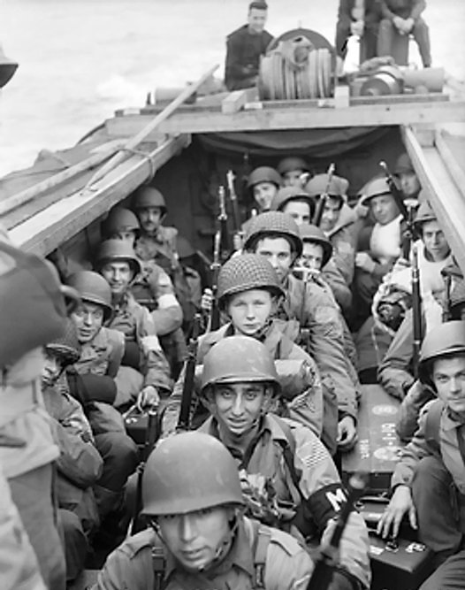
As the staging of forces continued from January thousands of men and equipment were staged across the United Kingdom. These forces launched the first allied amphibious operation from England, the invasion of North Africa, named Operation Torch. 18,500 U.S. Army combat troops were transported from their staging bases in the United Kingdom to Oran, North Africa. These men were part of the U.S. 1st Infantry Division (The Big Red One), the 1st Armored Division (Old Ironsides), and the 509th Parachute Infantry Regiment. Fighting would rage across North Africa, and many of these men would find themselves fighting from Sicily to the Italian mainland until the end of the War.
U.S. Troops embarked in a landing craft for Operation Torch. This artistic work was created by the Government of the United Kingdom before 1957 and is in the public domain.
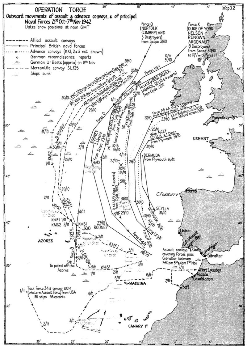
Map from “Operation Torch” by S. W. Roskill, from “The War at Sea 1939-1945”, Chapter XII. In the public domain.
The close proximity of Cambridgeshire and East Anglia to the industrial heart of Germany led to the development of numerous air fields for medium and heavy bombers, as well as fighter, cargo, and airborne support aircraft, arriving from the United States to work with RAF Bomber Command in the strategic bombing campaign against the Axis Powers.
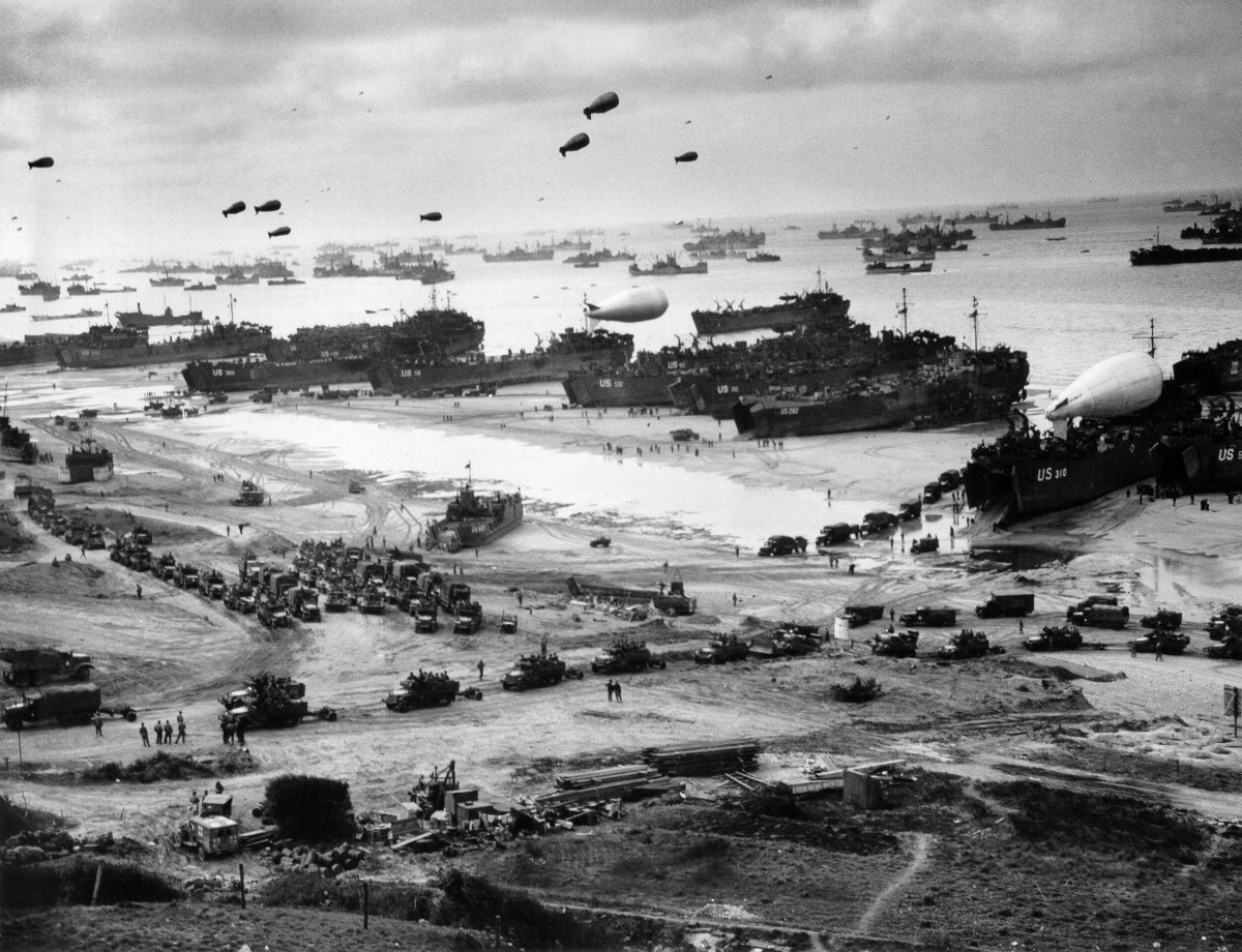
In June 1944, the long-awaited invasion of France was launched from staging points across England, with U.S., British, Commonwealth, and Allied troops storming the beaches of Normandy in Operation Overlord. These forces would drive on to liberate France, the Netherlands, Belgium and Luxembourg, and invade Germany, meeting the Soviet Allies on the Elbe. Amazingly, onboard over 1,200 aircraft and 5,000 ships, 160,000 allied troops were landed in France on June 6, 1944. By the end of August, 3 million allied troops were transported from England to France, a staggering feat of human achievement.
Mid-June 1944, a view of the immense logistical operation on Omaha Beach, Normandy France. The photo is the property of the U.S. Coast Guard and is in the public domain.
By the end of the war, 1.5 million U.S. servicemen and women had been stationed in England, or passed through to combat operations in Europe.
The military cooperation and deep relationship between the United Kingdom and the United States, which continues to this day, remained at the end of the Second World War. NATO was formed in response to new threats from the Soviet Union and its Allies, and the United Kingdom remained critical to Allied efforts through the Cold War. Today, almost two decades after the end of the Second World War, the presence of U.S. servicemen and women across Cambridgeshire is a point of pride for those of us who live here, reminded of our shared military history.
Halloween (or Hallowe’en, a shortening of Hallowed Evening, or the night before All Hallows’ Day) is now celebrated across Cambridgeshire to some extent – much depends on the village or the town’s desire to embrace a commercialized, but fun for the children, evening. In my local village, a anecdotal guess would be one out of four homes are open for trick-or-treaters – the wonderfully dressed children heading around in the dark looking for candy. In many ways Halloween is an English invention, born out of our pagan past in the Romanticism of the 19th Century, adopted and commercialized by the United States in the 20th Century, and now celebrated in England. This is an echo of an echo, for what we now see across the shires reflects more of America’s influence than our own English past. Where did Halloween come from?
Samhain was a Gaelic festival celebrating the end of the harvest and the beginning of the “darker” half of the year, traditionally celebrated across Ireland, Scotland, Wales, the Isle of Man and Brittany. A Celtic day began at sundown and Samhain would begin at sunset on 31 October and continue into the first of November. This date is midway between the winter solstice and the autumnal equinox, and the importance of it to the Celts can be seen in many Neolithic monuments oriented so that the rising sun on Samhain would shine on an opening or portal to a burial mound during the festival.
Many of our Halloween customs have come down from this event – it was a Celtic leminal time, where spirits and faeries from other worlds could cross over into our own, when bonfires were lit , and food and drink where left outside to satiate the spirits so that people and livestock would be left alone and survive the oncoming winter. There are echoes of our own customs here, but the Samhain festival would be Christianized in the Middle Ages and developed across the British Isles.
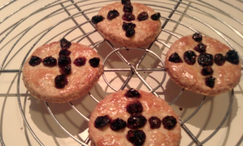
Soulcakes, the traditional treat given to children in England on Halloween, these are a descendent of Samhain gifts left outdoors for spirits. Notice the traditional Christian iconography of the cross. From Samantha, Haarlem, the Netherlands, in Wikimedia commons.
The Catholic Church celebrated All Saints Day on 1 November, followed by All Souls Day on 2 November. These two festivals of the church were blended into All Hallows’ Tide, the three day feast celebrating the dead saints, martyrs, and faithful which began on 1 November. It wasn’t a wild leap for the church to build on the Celtic customs observed across northern France and the British Isles, incorporating Samhain into a more Christianized feast. Interestingly, it was the descendants of Celts, the Scottish and Irish immigrants to the United States in the 19th Century that brought the celebration of Halloween to the New World – with many of its more pagan aspects expanded and grew. In England, “souling” or “guising”, dressing up and seeking out sweet cakes from the wealthy in exchange for praying for the dead, had existed from the Middle Ages.
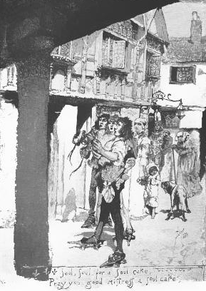
A postcard from 1882 showing dressed up or “souling” children seeking sweetcakes from wealthy townsmen in an English village. Titled “Souling on Halloween” by Mary Mapes Dodge, originally published in: “St. Nicholas: An Illustrated Magazine for Young Folks”, Scribner & Company, December 1882. In the public domain.
During the Romanticism of the 19th Century, Halloween was expanded and discussed across England, as fascination with Celtic mythology and druidism increased and a general rejection of Catholic feasts permeated British life. It was in the 20th Century that jack-o’-lanterns appeared, an effort to scare off evil spirits roaming through the night, building on carved gourds and vegetables seen in Ireland and Scotland.
In recent decades, the commercialization of this ancient holiday has spread across Cambridgeshire, brought back to England from a more enveloping American culture. The history of Halloween; however, reaches back into a pagan, pre-Christian Britain, when fear of spirits, faeries, and the dark, hungry times of winter were ubiquitous in our daily lives.
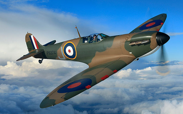
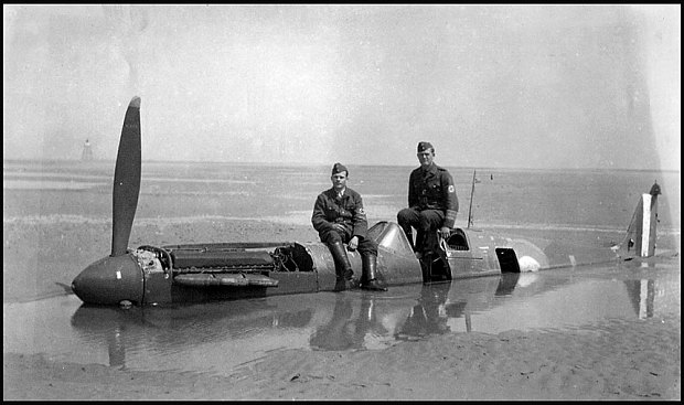
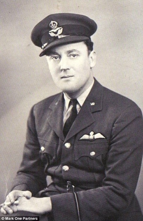
On May 24, 1940 a Dornier 17-Z bomber got a lucky hit on a MK1 Supermarine Spitfire P9374 during an air battle over the beaches of Dunkirk. The MK1 Spitfire, flown by Flying Officer Peter Cazenove had taken off from RAF Croydon and flown over northern France to support the fighting on the beaches of Dunkirk. The Dornier brought the Spitfire down with a single bullet, which then crash-landed gear-up on the beaches near Calais. Uninjured, Flying Officer Cazenove left the aeroplane and walked to Calais where he joined a British unit fighting in the waning days of the Battle of France. Eventually he was captured and made a POW, ending up in Stalag Luft III in eastern Germany and becoming involved in the Great Escape. Flying Officer Cazenove survived the War. The Spitfire; however, stayed on the beaches of Dunkirk along with so much British military kit abandoned in the evacuation. Remarkably, a picture survives of two German servicemen sitting on the wreckage of P9374, half buried in the sand.
Eventually the tides coming in and out over Dunkirk buried the aeroplane where it was preserved for the next several decades until September 1980 when the fighter appeared back above the sands. Lovingly restored and reassembled by experts and now at the Imperial War Museum in Duxford, Cambridgeshire, the Spitfire is now one of only two flying MK1 Spitfires in their original specifications (there are many other flying Spitfires of different variants).
MK 1 Spitfire P9374 was built in 1939. Its Merlin III engine was completed at the Rolls-Royce Factory in Derby on October 27, 1939. The aeroplane had only 32 hours of flying time when it was brought down over France. It was one of the renowned No. 92 Squadron’s fighters based at RAF Croydon in March 1940.
Amazingly, this aeroplane is going on sale. On July 9, 2015 at Christie’s in London, P9374 will go on sale and is expected to fetch between £2- £2.5 million. The proceeds of the sale will be shared between two charities – the Royal Air Force Benevolent Fund and Panthera Corporation, a wildlife conservation charity Mr Thomas Kaplan and his wife, Ms Dafna Kaplan, founded in 2006. Mr Kaplan, an American billionaire investor who is a world renowned conservationist, art collector, and Oxfordian, is the generous individual behind the sale. The second flying MK1 Spitfire in the world was also restored by Mr Kaplan’s experts. Numbered N3200, he has generously donated the MK1 Spitfire to the Imperial War Museum, Duxford, where it often flies and is available to all visitors to admire.
One of the greatest military aviation sites in the World is the Imperial War Museum, Duxford. Located off the M11, south of Cambridge, on the site of historic RAF Duxford. http://www.iwm.org.uk/visits/iwm-duxford
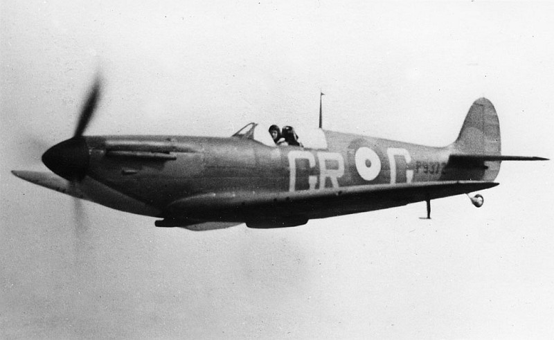
One of her sister aircraft, MK1 Supermarine Spitfire P9372. An early photo of a No. 92 Squadron Spitfire Mk1, The GR codes date it to the Spring of 1940 and the lack of an armour plated windscreen dates it to before the evacuation of Dunkirk. P9372 was shot down over Rye in September 1940. The wreck was recovered and much of the aeroplane is on display at Biggin Hill Heritage Hangar. Unknown Photographer.
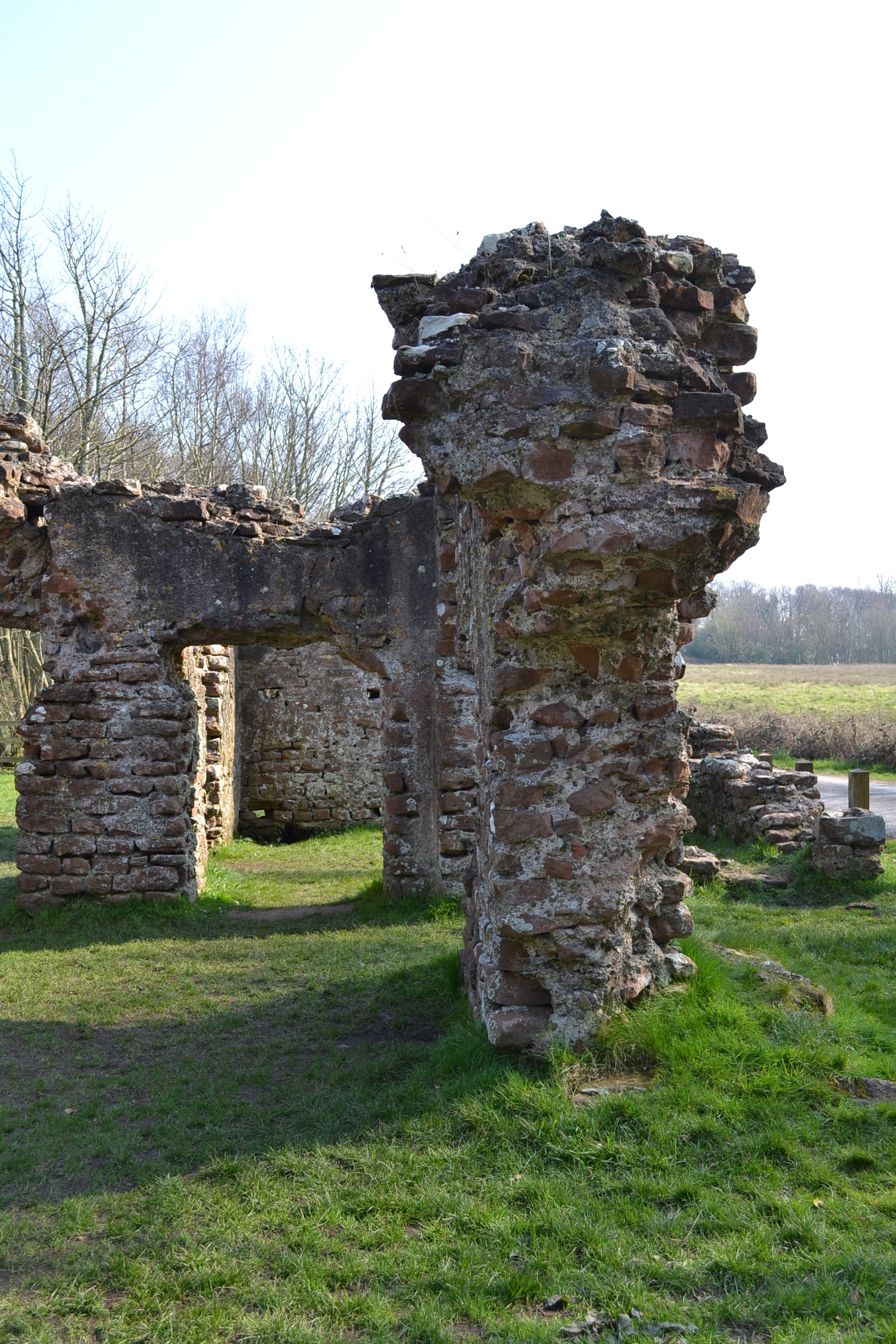
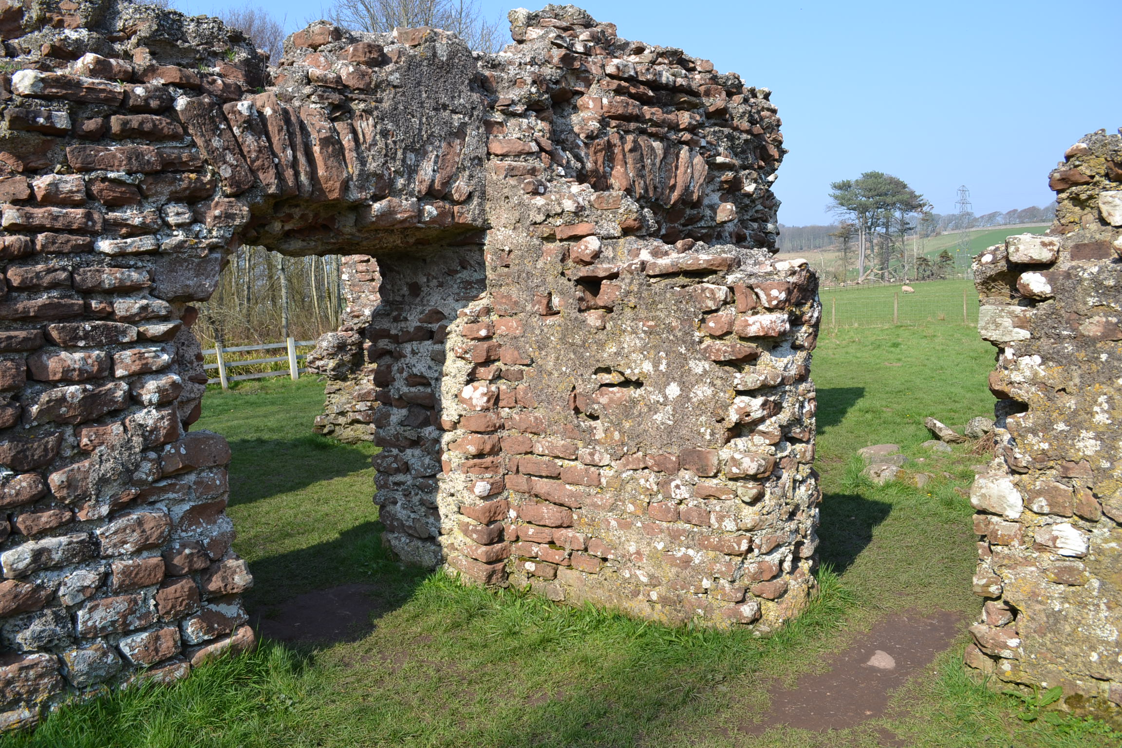
Traveling west from Hardknott Pass (and the Roman Fort I recently blogged about) down to the coast of the Irish Sea is the modern village of Ravenglass – the Roman Port of Glannaventa. Almost two millennia ago, this was a key port in Roman Britain. Glannaventa connected the border fortresses with the maritime supply lines essential for supporting the garrisons with food, supplies, and reinforcements. These forts protected the northern border of the empire before Hadrian’s Wall was constructed. The port was also necessary for the export of silver and lead mined in the Lake District to mainland Europe and the greater Roman Empire. As is often the case with important centres of trade, the port thrived and grew alongside the military encampments, eventually leisure facilities were constructed.
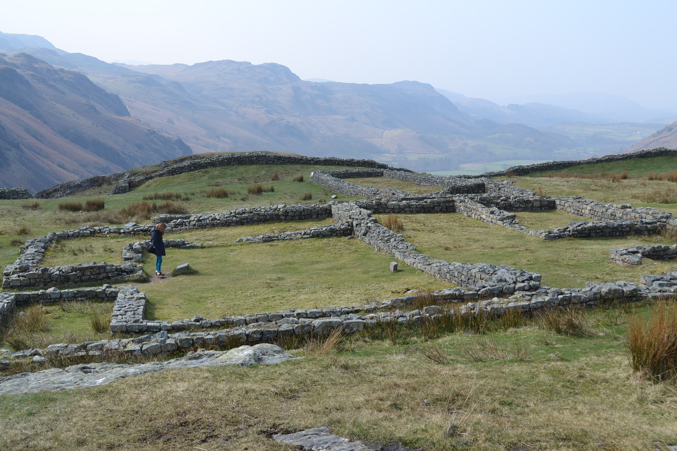
On the outskirts of the Roman town stood a sprawling bath house or Thermae in Latin, which is remarkably still standing and carefully preserved. Brick walls 13 feet (4 meters) high remain, with curved arches over doorways. Under the earth are additional foundations, visible now only under the raised ground, but clearly showing the impressive size of the bath house. The Thermae stood next to a large fort, which is now buried in the Cumbrian landscape – some of the village, roads, and a railway all cross the archaeological site. However, the initial excavations from 1881 have been expanded in recent years and it now appears the extent of the Roman encampment is greater than once believed. Just south of the bath house, along a public foot path which crosses the rail line, work is being conducted on the foundations of barracks which once housed the garrison of Glannaventa.
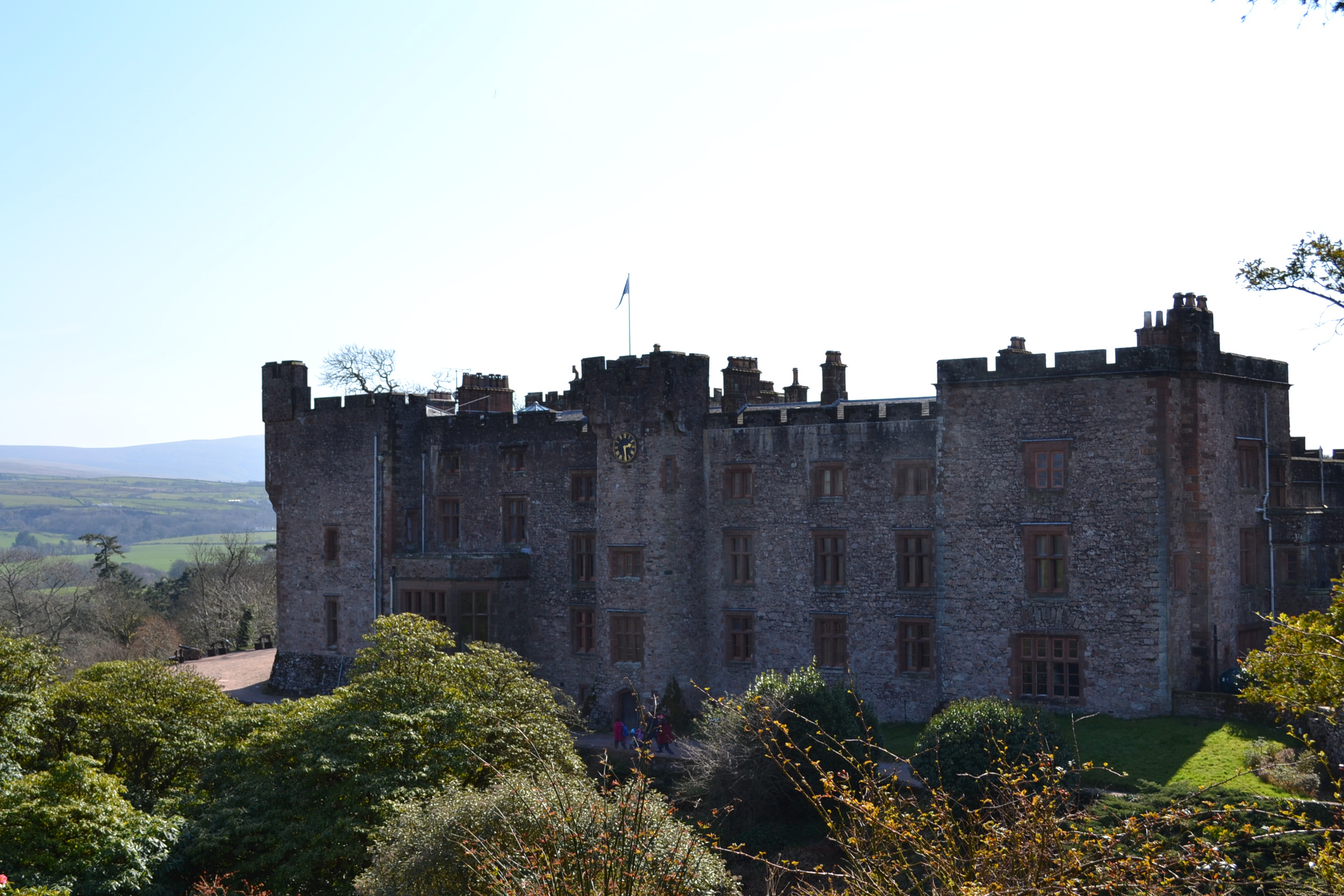
Of note, a mile’s walk from the Bath House is Muncaster Castle, home of the Pennington Family and the Barons Muncaster. The beautiful castle, occupied by the Pennington family for over 800 years, is built on an elevated wall which is now believed to have been a Roman fortification – the ruins of which were used as the foundations of the castle.
The Ravenglass Roman Bath House is maintained by English Heritage, there is free access and free parking. Muncaster Castle is a beautiful and historic Grade I property which is certainly worth a full day’s visit to enjoy the house and gardens: http://www.muncaster.co.uk.
After much traveling, I plan on returning to Cambridgeshire soon… Brandon.
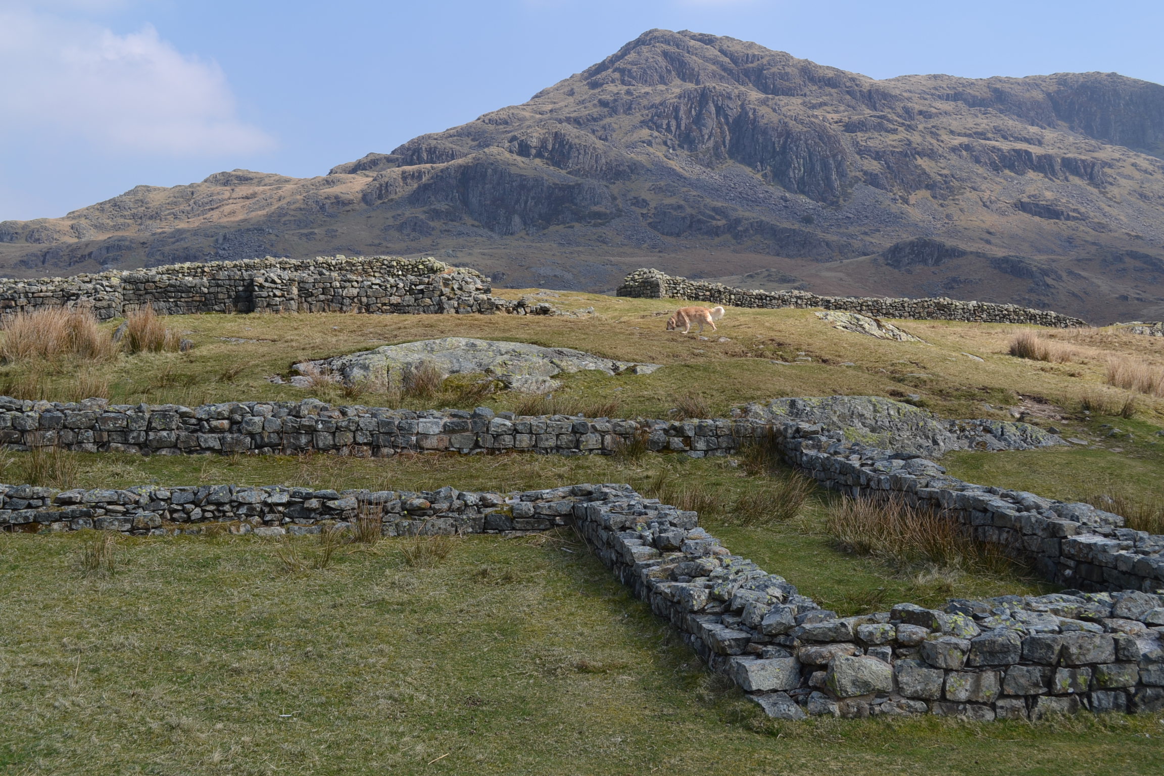
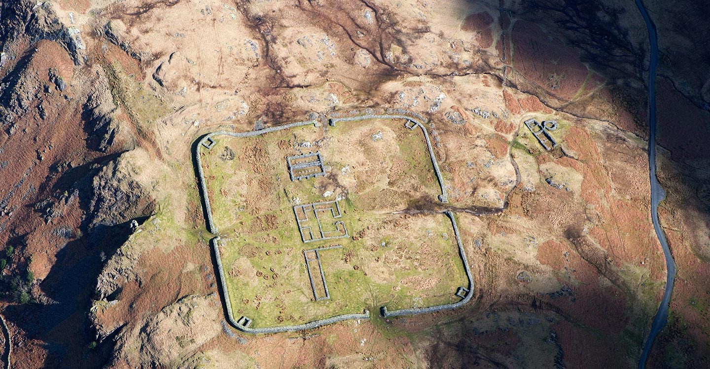
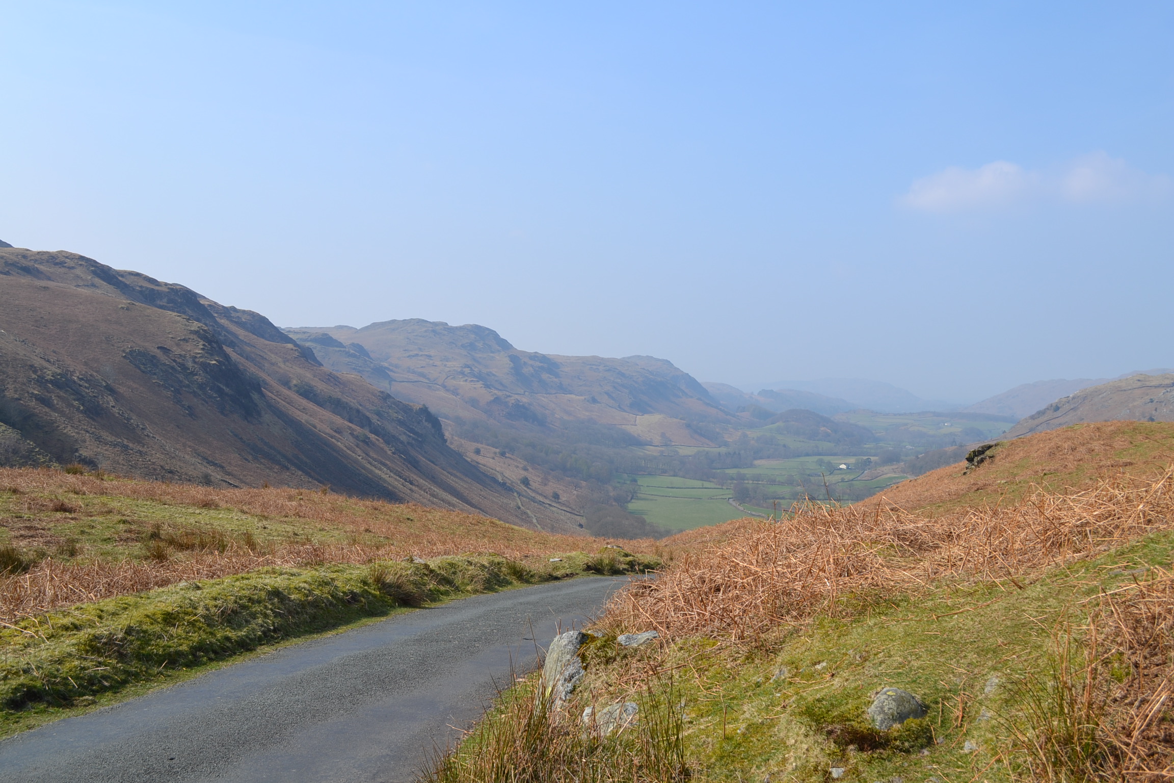
High in the mountain passes of the Lake District in northwest England, some distance from Cambridgeshire, lies a long ruined Roman fortress that once guarded the northern borders of the Roman Empire. It is hard to imagine a time when the beauty and tranquillity of Cumbria, now so often visited by hikers and outdoor enthusiasts, was a battlefield. In the early Second Century, during the reign of Emperor Hadrian, the Mediobogdum Fort was constructed along a chain of fortifications to prevent an invasion of Roman Britain (we are reasonably sure that Mediobogdum is now identified as the Hardknott Roman Fort). It was built along the mountain pass that left the port of Glannoventa (modern day Ravenglass) in the Eskdale Valley and crossed the hardknott mountain towards Windermere. Nowadays, the single-track road is notorious as the steepest and most treacherous mountain track in all of Great Britain, loved by motoring enthusiasts. One can imagine at the difficulty of garrisoning, supplying and constructing a military encampment high in the mountains of the Lake District – what is even difficult to access by auto today.
This fort, built and occupied before Hadrian’s Wall was constructed several miles to the North, was at its time the last outpost of Empire – almost a thousand miles from the Imperial City of Rome. The remoteness of this posting would have been breath-taking for the 500 men and officers garrisoned here – who we know from extant Roman records were the Fourth Cohort of Dalmatians. These men were raised on the balmy eastern shores of the Adriatic Sea (present day Slovenia, Croatia, Montenegro, and Albania). They would have travelled overland across Europe and then sailed to western England to reach this hostile borderland, where conflict with Picts and other tribes from present day Scotland was a constant threat.
Laid out with military precision, it is still easy to walk the perfect square of Hardknott Fort, 110 meters per wall, with four gates and corner towers. The road of the day would have entered the fort via one gate and led travellers, merchants, and local peasants out through the opposite, ensuring the soldiers could maintain control of the key mountainous terrain, the movement of people and goods, and the levying of customs taxes. One nowadays can walk through the foundations of the Commanding Officer’s Praetorium, or villa. You can easily picture the wooden supports that would have comprised the barracks for the soldiers, junior officers, and auxiliaries, and think on the remoteness of this post. The foundations of the headquarters building, the granaries, and the forementioned Praetorium occupy the central ground of the fort. Just outside the northern gate is a parade field, a testament to the Roman Empire’s renowned discipline of its troops. A bit farther afield the ruins of a bath house remain, a reminder that not all of life in Mediobogdum would have been austere and grim.
Today, Hardknott Fort is jointly preserved by both English Heritage and the National Trust. Not easily accessible, you must navigate the Hardknott Pass and then hike to the Fort, which is perched on the middle slopes of the Hardknott peak. Visit: http://www.english-heritage.org.uk/visit/places/hardknott-roman-fort/ for more information on the fort.