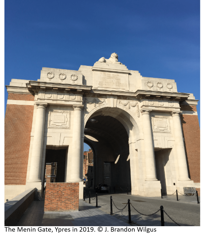
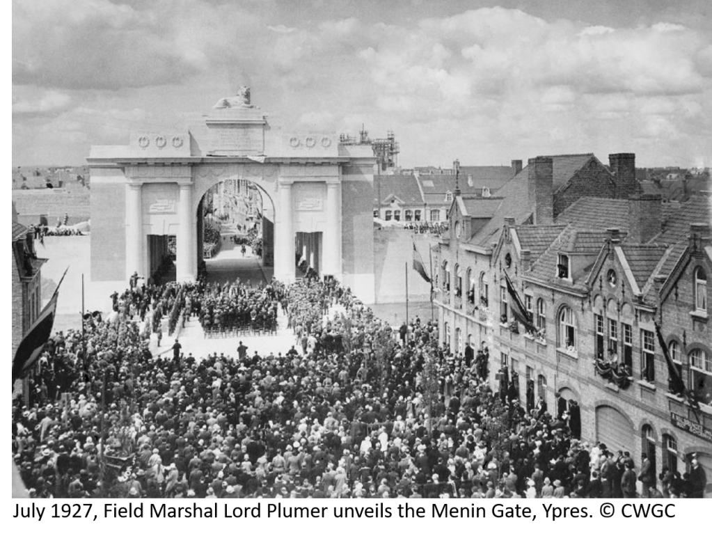
It is a somber place, the Ypres Salient, where so many young men perished between 1914 and 1918. I have begun a series of hikes around the many battlefields, following Paul Reed’s excellent guide: “Walking Ypres”. However, my exploration of the Ypres Salient rightly begins at the Menin Gate, a memorial to the British and Commonwealth soldiers missing from the beginning of the war until 15 August 1917. It was then that 55,000 names of missing men had been reached and additional names would be recorded on other memorials around the Salient. However, for the missing from Commonwealth countries: Australia, Canada, and South Africa, all their missing from the Ypres Salient are recorded at the Menin Gate. The memorial was built in the 1920s and unveiled in July of 1927. At the unveiling of the monument, Field Marshal Herbert Plumer, 1st Viscount Plumer, who had led forces in the Salient during the war, most notably at Messines Ridge, famously said of those with no graves: “They are not missing, they are here.”
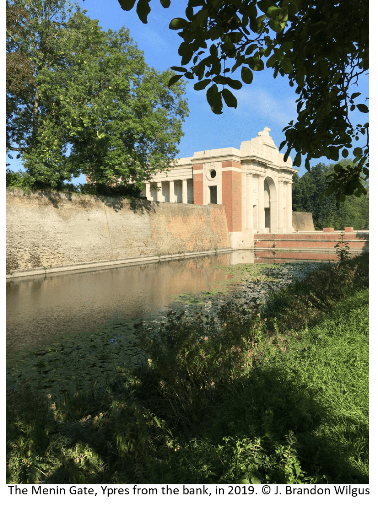
Originally, the gate was an opening in the 17th Century walls built by Vauban which led from the medieval market town of Ypres to the town of Menin some miles away to the east. During the war, the opening in the walls led to the front, and as the war progressed, hundreds of thousands of men would pass from the town through the destroyed portal to the trenches and dugouts which surrounded the tenuous British position in the salient. Ypres itself came under increased German shelling throughout the war and was almost completely destroyed by the armistice in 1918. Soldiers passing from Ypres through the ruined walls to the trenches were said to joke: “tell the last man through to bolt the Menin Gate.”
Beginning in July 1928, only interrupted during the German occupation during the Second World War, the Last Post Buglers’ Association has played the Last Post at 8 pm each evening under the arch of the Menin Gate. In fact, as Ypres was liberated by Polish forces in the Second World War, the ceremony was bravely resumed by local firefighters while fighting continued in the town. It is a moving ceremony and a credit to the Belgian allies of Great Britain, the citizens of Ypres, who have maintained this somber tradition for almost a hundred years. Each night, traffic is stopped and visitors stand silently as the buglers play in unison the Last Post, which echoes under the gate and among the 55,000 names of the missing. It is fitting to feel overcome by a sense of loss and tragedy at such a moment.
An amazing thing recently happened. A friend of mine, stationed at RAF Molesworth, the old airbase of the 303rd Bomb Group (H) in the western part of Cambridgeshire, came by my office. He brought me a box of old photographs – all photos from airmen and officers of the 303rd, part of U.S. 8th Air Force, taken during the Second World War at RAF Molesworth. He asked if I wanted them. Of course! I was amazed. They are wonderful historical records. On top of the stack of photos – there must be 70 – there was a handwritten note, which read: “Dupes of WWII photos donated by Malcolm Magid, plus copies from old JAC XO, CAPT Mewbourne.” This note tells me quite a few things, namely the photos were in the possession of the Joint Analysis Centre (JAC) Executive Officer (XO), who was a naval officer (the acronym CAPT is only used for a U.S. Navy Captain, the other branches of the U.S. military use different acronyms: Capt., CPT, or Capt). The JAC command has only been at Molesworth since 1990 – so that gives some idea of the timeline of the photos ownership.
More importantly, Mr. Malcolm James Magid was a B-17 co-pilot who survived the war and passed away in Atlanta, Georgia on 16 May 2012 at the age of 88. He was stationed at RAF Molesworth and flew 35 missions over Germany during the War. He was highly decorated, even being made a Chevalier of the Légion d’honneur by the President of France for his aid in the Republic’s liberation.
2LT Malcolm Magid Service Photo, thanks to the 303rd BG(H) Historical Society
For the photos themselves, I asked myself what to do? First, I thought I will scan them in and post them here as a record of the brave men who served at RAF Molesworth, and in honour of Mr. Magid. Secondly, I will attempt to find Mr. Magid’s family (an obituary published in a local paper lists his descendants) and see if they would like these photos returned. If that effort is unsuccessful, I will contact the U.S. Air Force Historical Society and the 303rd Bomb Group Historical Society to see if the photos can be added to their collections. More to follow.
For now, please enjoy these photographs. I think you may feel as I do that these men are all so very young…
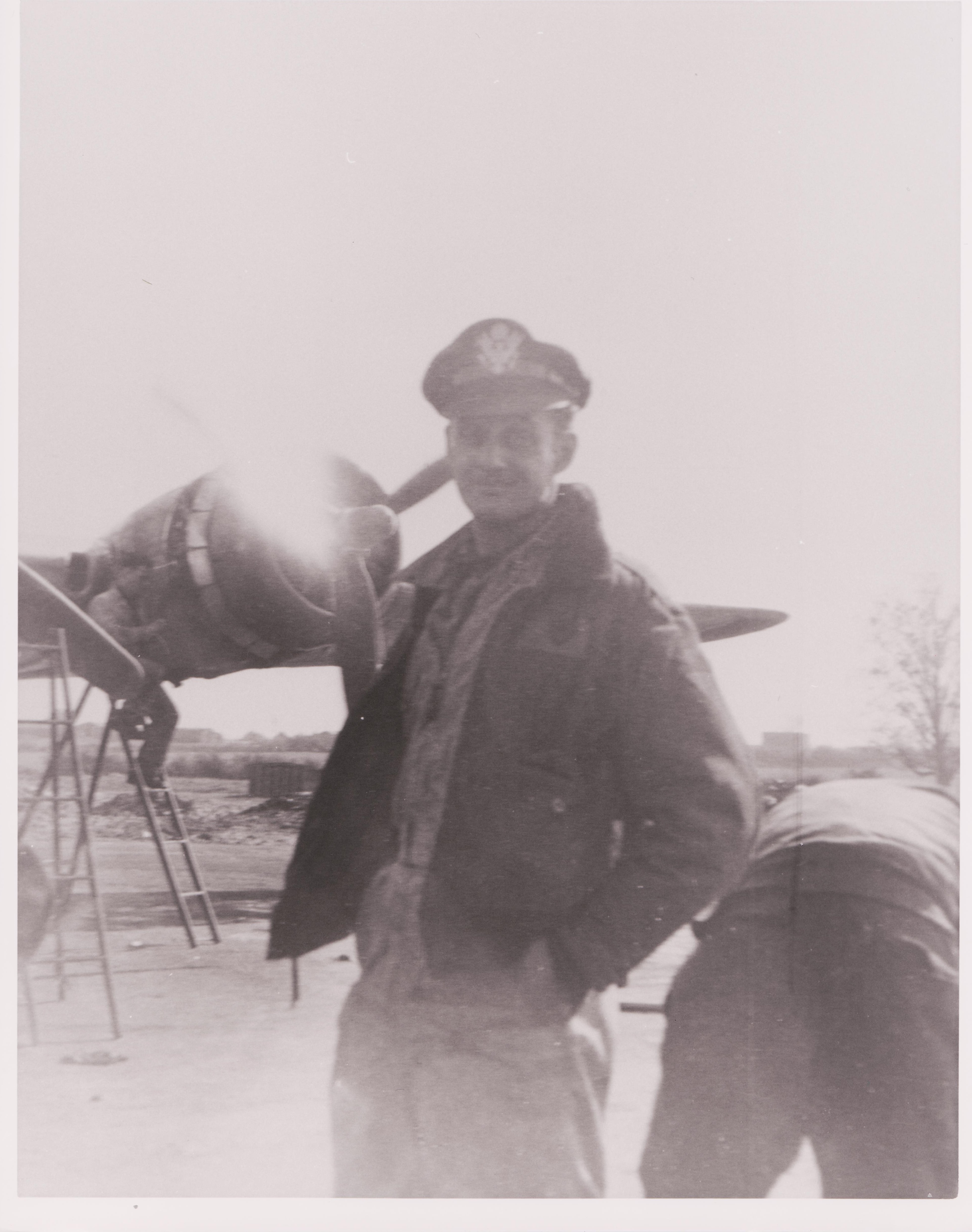
This appears to be 2LT Malcolm Magid standing infront of a B-17 undergoing maintenance.
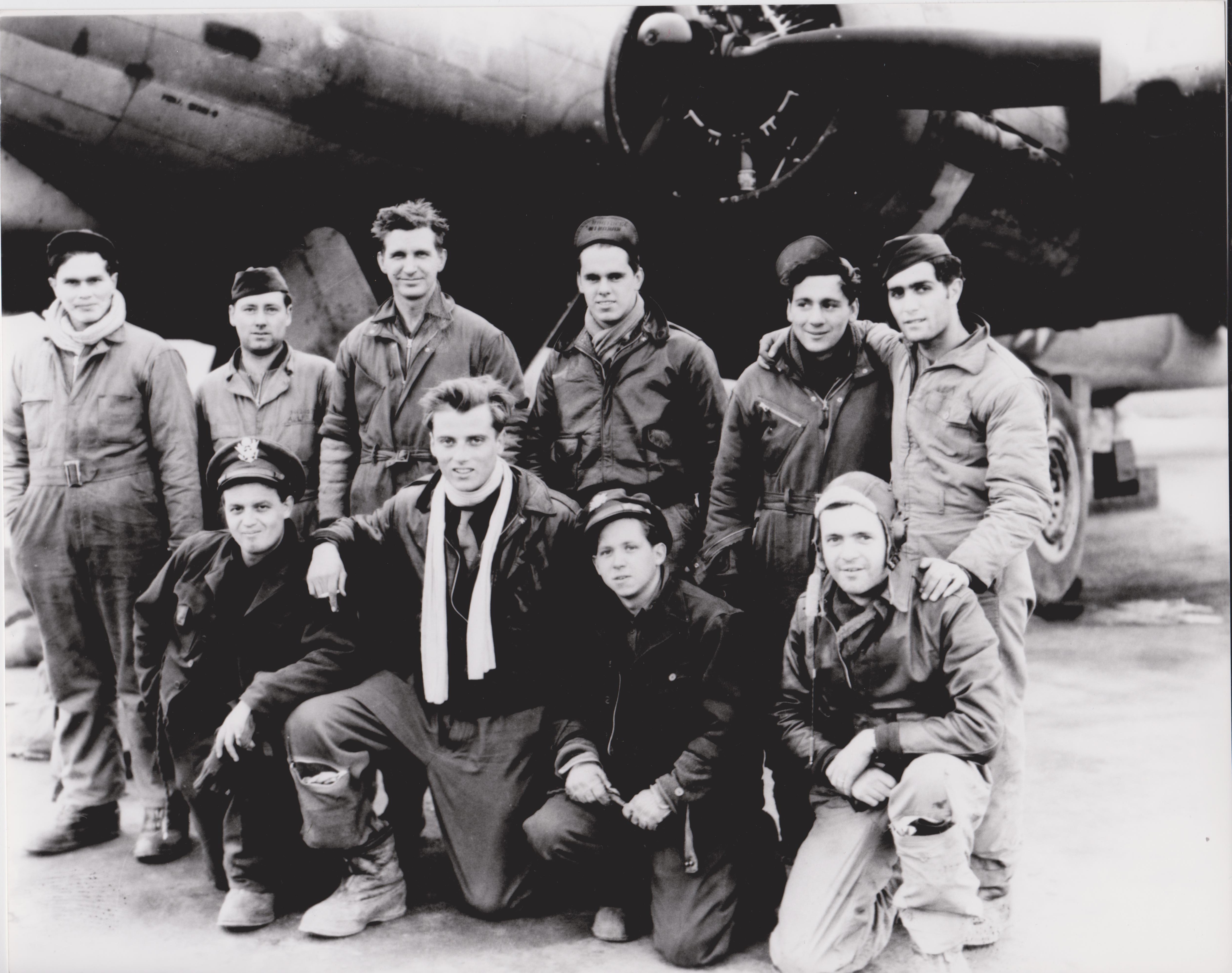
B-17 Crew in front of aircraft. I am (moderately) confident that 2LT Magid is kneeling in the front row on the far left, wearing the peaked cap. The officer in the front row, third from left, is striking in how young he looks.
B-17 Cockpit.
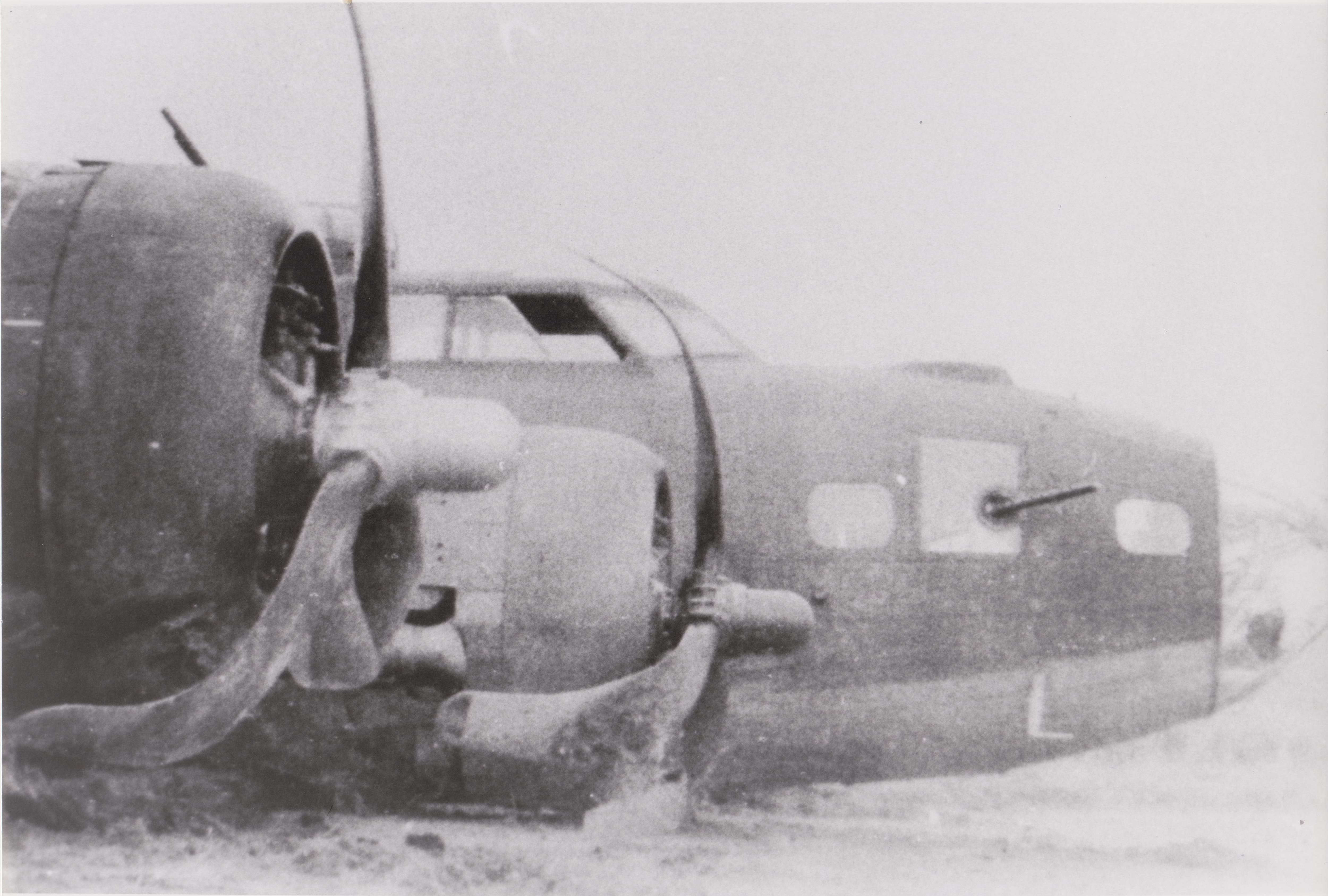
Photo of a B-17 after making a wheels-up landing (the aircraft is in remarkable shape).
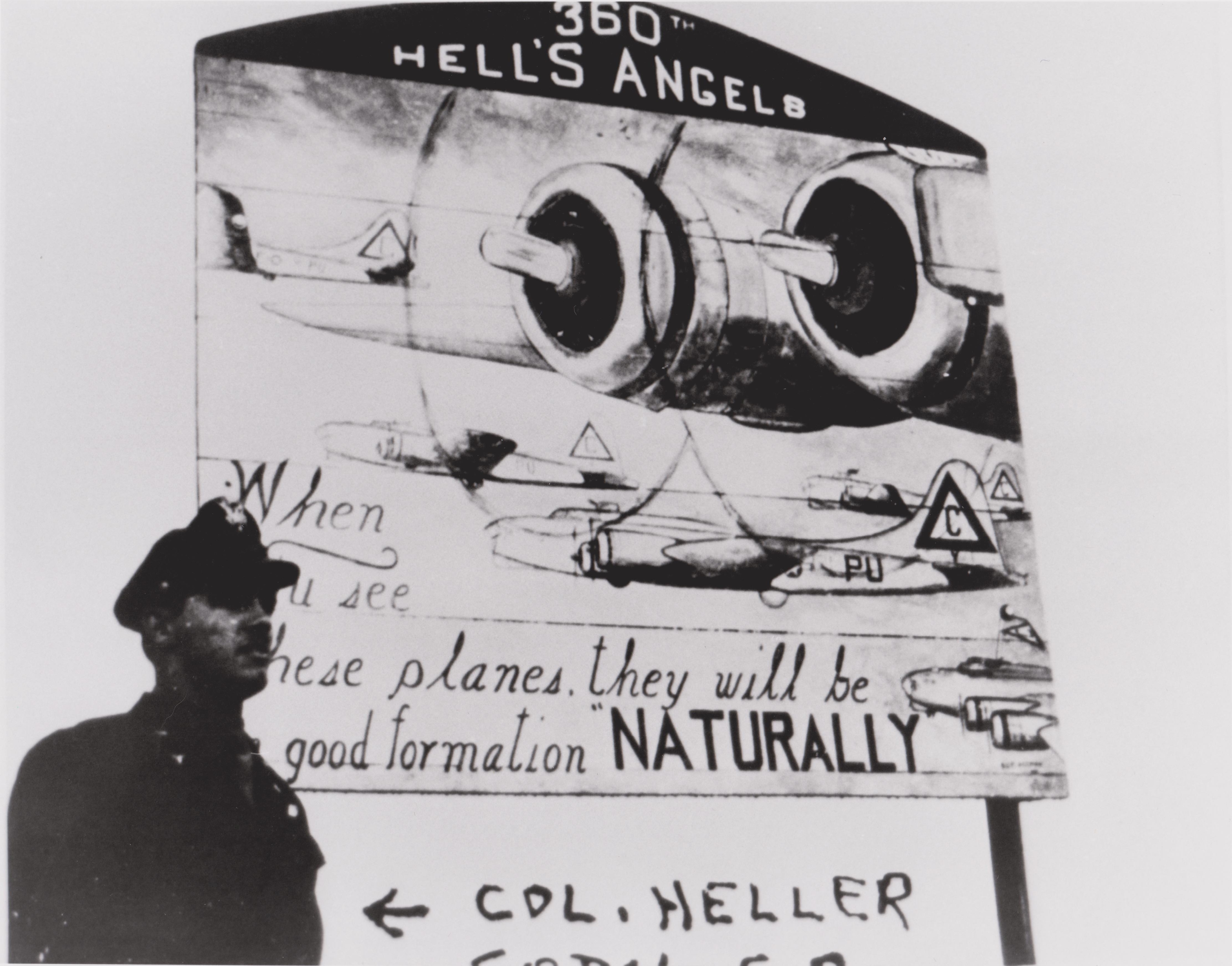
Written on the negative is “COL. Heller… [illegible]” Colonel Heller was the 360th Squadron Commanding Officer, a subordinate unit to the 303rd Bomb Group (H).
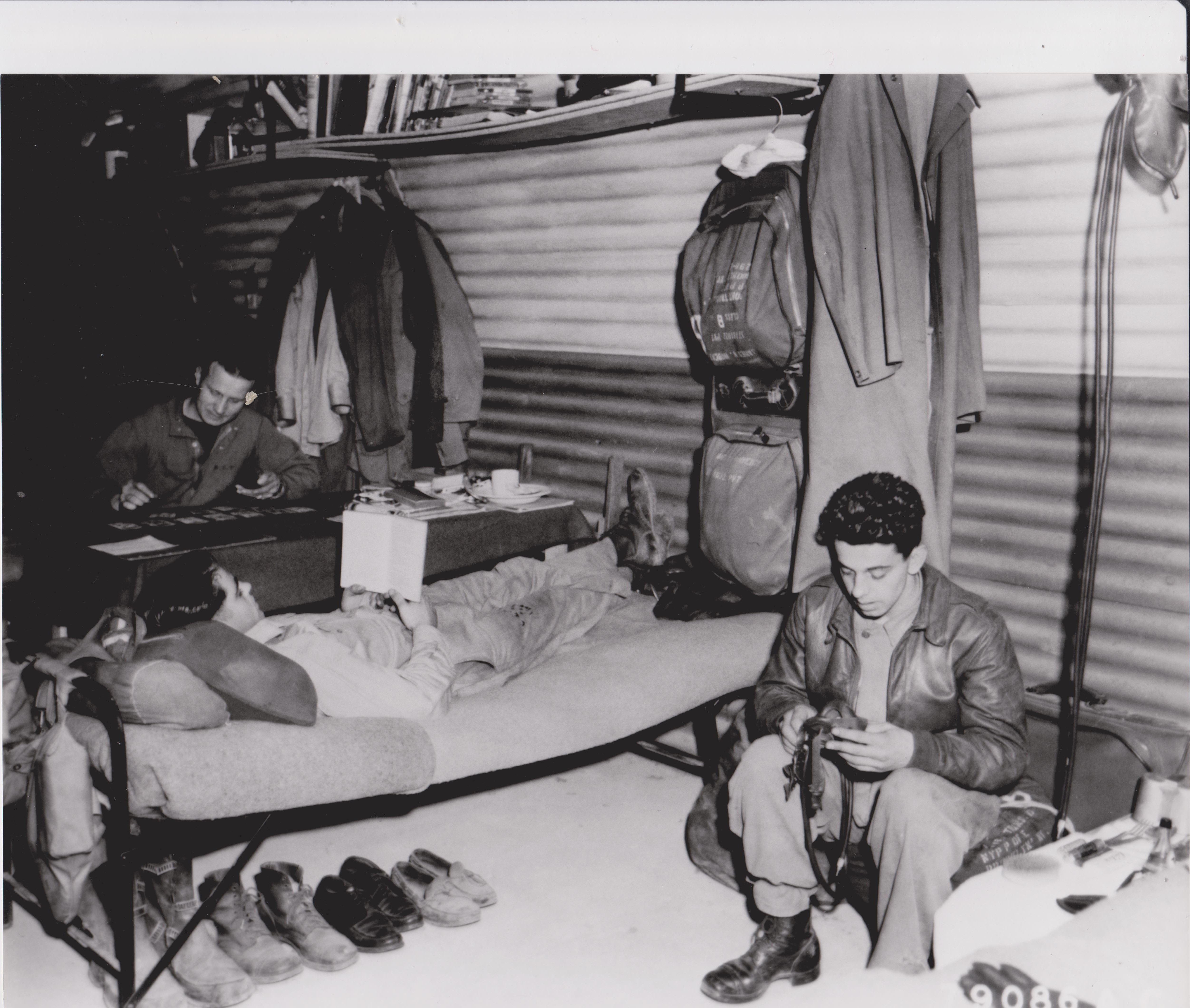
Inside a Nissen Hut. Of note: under the cot are flying boots, uniform dress shoes, and tasselled loafers. The airman in the background is playing solitaire.
One of the interesting things about living in Cambridgeshire is seeing the uniforms of U.S. servicemen and women stationed here in England. Many of these men and women serve in the U.S. Air Force, on Royal Air Force Bases, across East Anglia and the East of England. However, it wasn’t too many decades past when U.S. Army and Navy personnel were commonly seen in England as well, especially during the Second World War. Even before the attack on Pearl Harbor and the United States entering the war in December 1941, there were high-level contacts at the General Staff level between the United States and United Kingdom. In fact, as early as March 1941, the United States, United Kingdom and Canada had agreed on: “The early defeat of Germany as the predominant member of the Axis with the principal military effort of the United States being exerted in the Atlantic and European area; and a strategic defensive in the Far East.” – this was the Europe First policy which was the basis of the Allied war effort throughout the Second World War. So when the attack on Pearl Harbor came and the United States found itself at war with the Axis Powers: Germany, Japan, and Italy, it was only a short amount of time before U.S. Army and U.S. Army Air Corps (the forerunner of the U.S. Air Force) personnel began arriving in droves across England.
It was on January 26, 1942 that the first U.S. combat troops arrived in England. As U.S. forces arrived in England, they were handed a publication titled: “Instructions for American Servicemen in Britain”. Along with all sorts of useful advice to help with the large influx of Americans, servicemen were told never to insult the monarchy, and that “the British don’t know how to make a good cup of coffee, but you don’t know how to make a good cup of tea. It’s an even swap.” It is important to note that individual Americans were serving with UK and Canadian units across England in units like the Eagle Squadrons, but the organized landing of forces of the U.S. Army did not occur until January 1942.
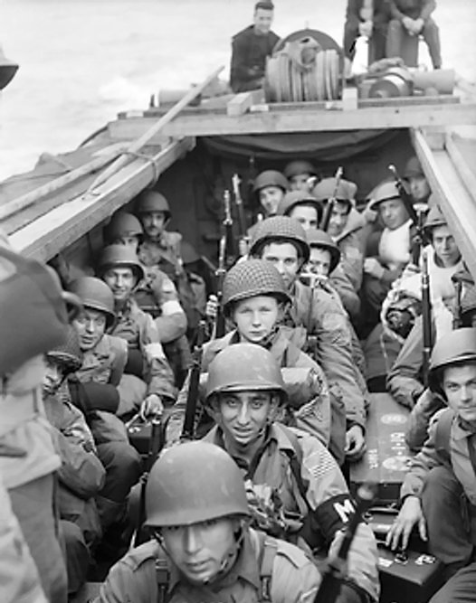
As the staging of forces continued from January thousands of men and equipment were staged across the United Kingdom. These forces launched the first allied amphibious operation from England, the invasion of North Africa, named Operation Torch. 18,500 U.S. Army combat troops were transported from their staging bases in the United Kingdom to Oran, North Africa. These men were part of the U.S. 1st Infantry Division (The Big Red One), the 1st Armored Division (Old Ironsides), and the 509th Parachute Infantry Regiment. Fighting would rage across North Africa, and many of these men would find themselves fighting from Sicily to the Italian mainland until the end of the War.
U.S. Troops embarked in a landing craft for Operation Torch. This artistic work was created by the Government of the United Kingdom before 1957 and is in the public domain.
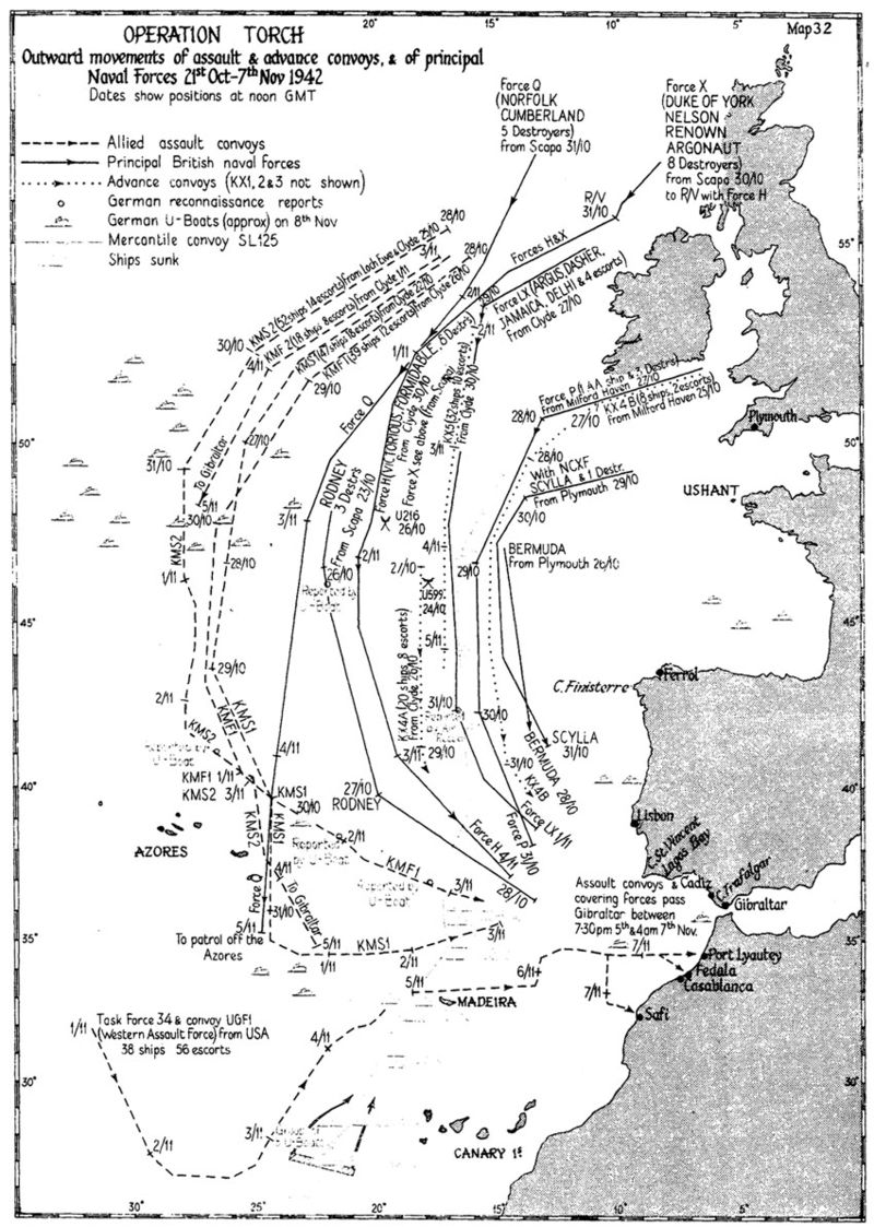
Map from “Operation Torch” by S. W. Roskill, from “The War at Sea 1939-1945”, Chapter XII. In the public domain.
The close proximity of Cambridgeshire and East Anglia to the industrial heart of Germany led to the development of numerous air fields for medium and heavy bombers, as well as fighter, cargo, and airborne support aircraft, arriving from the United States to work with RAF Bomber Command in the strategic bombing campaign against the Axis Powers.
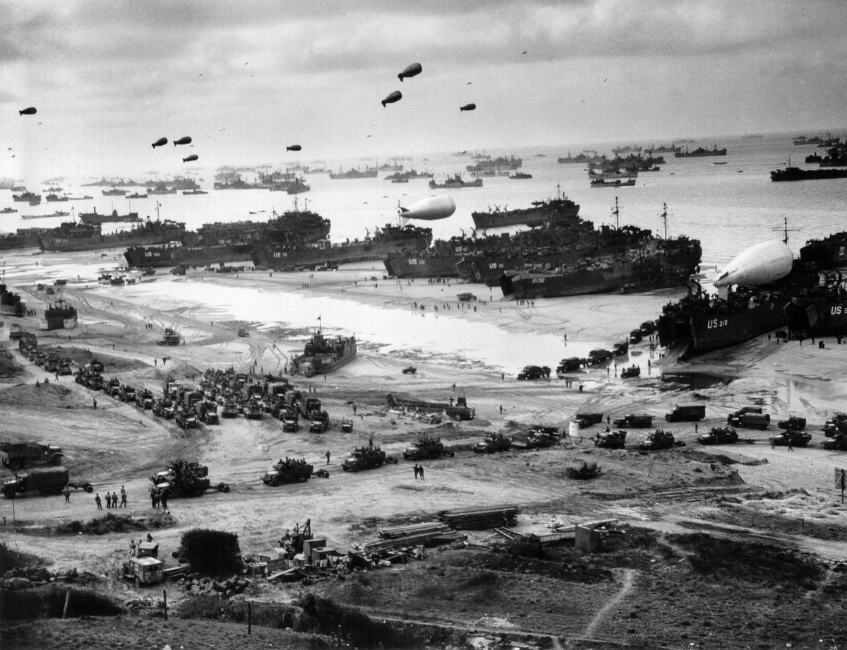
In June 1944, the long-awaited invasion of France was launched from staging points across England, with U.S., British, Commonwealth, and Allied troops storming the beaches of Normandy in Operation Overlord. These forces would drive on to liberate France, the Netherlands, Belgium and Luxembourg, and invade Germany, meeting the Soviet Allies on the Elbe. Amazingly, onboard over 1,200 aircraft and 5,000 ships, 160,000 allied troops were landed in France on June 6, 1944. By the end of August, 3 million allied troops were transported from England to France, a staggering feat of human achievement.
Mid-June 1944, a view of the immense logistical operation on Omaha Beach, Normandy France. The photo is the property of the U.S. Coast Guard and is in the public domain.
By the end of the war, 1.5 million U.S. servicemen and women had been stationed in England, or passed through to combat operations in Europe.
The military cooperation and deep relationship between the United Kingdom and the United States, which continues to this day, remained at the end of the Second World War. NATO was formed in response to new threats from the Soviet Union and its Allies, and the United Kingdom remained critical to Allied efforts through the Cold War. Today, almost two decades after the end of the Second World War, the presence of U.S. servicemen and women across Cambridgeshire is a point of pride for those of us who live here, reminded of our shared military history.
Halloween (or Hallowe’en, a shortening of Hallowed Evening, or the night before All Hallows’ Day) is now celebrated across Cambridgeshire to some extent – much depends on the village or the town’s desire to embrace a commercialized, but fun for the children, evening. In my local village, a anecdotal guess would be one out of four homes are open for trick-or-treaters – the wonderfully dressed children heading around in the dark looking for candy. In many ways Halloween is an English invention, born out of our pagan past in the Romanticism of the 19th Century, adopted and commercialized by the United States in the 20th Century, and now celebrated in England. This is an echo of an echo, for what we now see across the shires reflects more of America’s influence than our own English past. Where did Halloween come from?
Samhain was a Gaelic festival celebrating the end of the harvest and the beginning of the “darker” half of the year, traditionally celebrated across Ireland, Scotland, Wales, the Isle of Man and Brittany. A Celtic day began at sundown and Samhain would begin at sunset on 31 October and continue into the first of November. This date is midway between the winter solstice and the autumnal equinox, and the importance of it to the Celts can be seen in many Neolithic monuments oriented so that the rising sun on Samhain would shine on an opening or portal to a burial mound during the festival.
Many of our Halloween customs have come down from this event – it was a Celtic leminal time, where spirits and faeries from other worlds could cross over into our own, when bonfires were lit , and food and drink where left outside to satiate the spirits so that people and livestock would be left alone and survive the oncoming winter. There are echoes of our own customs here, but the Samhain festival would be Christianized in the Middle Ages and developed across the British Isles.
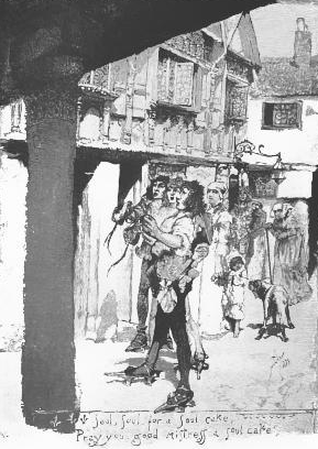
Soulcakes, the traditional treat given to children in England on Halloween, these are a descendent of Samhain gifts left outdoors for spirits. Notice the traditional Christian iconography of the cross. From Samantha, Haarlem, the Netherlands, in Wikimedia commons.
The Catholic Church celebrated All Saints Day on 1 November, followed by All Souls Day on 2 November. These two festivals of the church were blended into All Hallows’ Tide, the three day feast celebrating the dead saints, martyrs, and faithful which began on 1 November. It wasn’t a wild leap for the church to build on the Celtic customs observed across northern France and the British Isles, incorporating Samhain into a more Christianized feast. Interestingly, it was the descendants of Celts, the Scottish and Irish immigrants to the United States in the 19th Century that brought the celebration of Halloween to the New World – with many of its more pagan aspects expanded and grew. In England, “souling” or “guising”, dressing up and seeking out sweet cakes from the wealthy in exchange for praying for the dead, had existed from the Middle Ages.
A postcard from 1882 showing dressed up or “souling” children seeking sweetcakes from wealthy townsmen in an English village. Titled “Souling on Halloween” by Mary Mapes Dodge, originally published in: “St. Nicholas: An Illustrated Magazine for Young Folks”, Scribner & Company, December 1882. In the public domain.
During the Romanticism of the 19th Century, Halloween was expanded and discussed across England, as fascination with Celtic mythology and druidism increased and a general rejection of Catholic feasts permeated British life. It was in the 20th Century that jack-o’-lanterns appeared, an effort to scare off evil spirits roaming through the night, building on carved gourds and vegetables seen in Ireland and Scotland.
In recent decades, the commercialization of this ancient holiday has spread across Cambridgeshire, brought back to England from a more enveloping American culture. The history of Halloween; however, reaches back into a pagan, pre-Christian Britain, when fear of spirits, faeries, and the dark, hungry times of winter were ubiquitous in our daily lives.
Traveling west from Hardknott Pass (and the Roman Fort I recently blogged about) down to the coast of the Irish Sea is the modern village of Ravenglass – the Roman Port of Glannaventa. Almost two millennia ago, this was a key port in Roman Britain. Glannaventa connected the border fortresses with the maritime supply lines essential for supporting the garrisons with food, supplies, and reinforcements. These forts protected the northern border of the empire before Hadrian’s Wall was constructed. The port was also necessary for the export of silver and lead mined in the Lake District to mainland Europe and the greater Roman Empire. As is often the case with important centres of trade, the port thrived and grew alongside the military encampments, eventually leisure facilities were constructed.
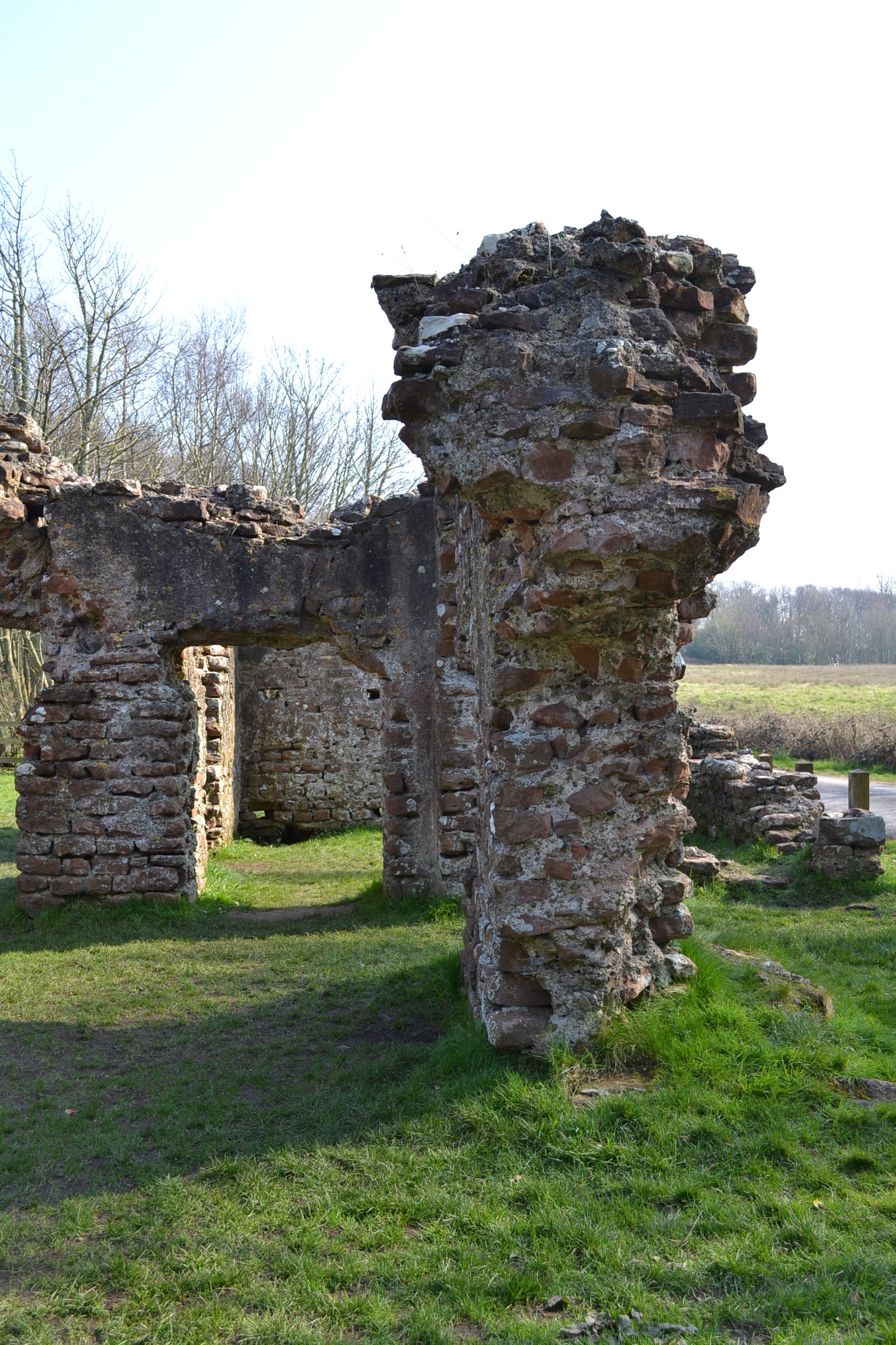
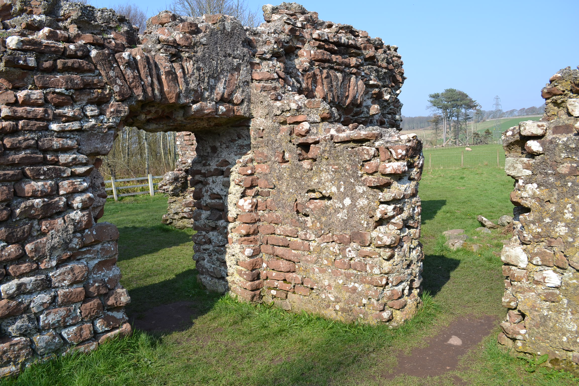
On the outskirts of the Roman town stood a sprawling bath house or Thermae in Latin, which is remarkably still standing and carefully preserved. Brick walls 13 feet (4 meters) high remain, with curved arches over doorways. Under the earth are additional foundations, visible now only under the raised ground, but clearly showing the impressive size of the bath house. The Thermae stood next to a large fort, which is now buried in the Cumbrian landscape – some of the village, roads, and a railway all cross the archaeological site. However, the initial excavations from 1881 have been expanded in recent years and it now appears the extent of the Roman encampment is greater than once believed. Just south of the bath house, along a public foot path which crosses the rail line, work is being conducted on the foundations of barracks which once housed the garrison of Glannaventa.
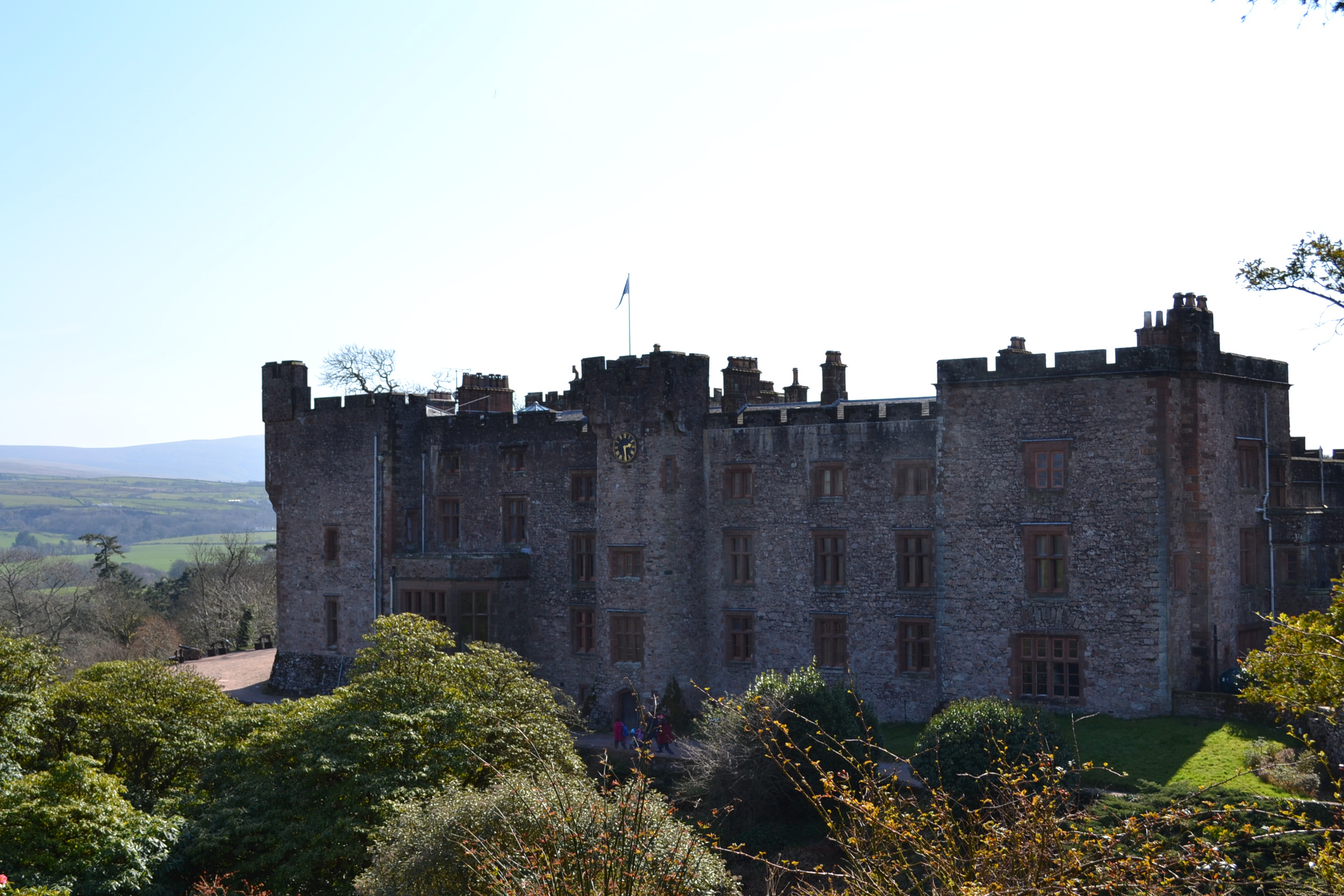
Of note, a mile’s walk from the Bath House is Muncaster Castle, home of the Pennington Family and the Barons Muncaster. The beautiful castle, occupied by the Pennington family for over 800 years, is built on an elevated wall which is now believed to have been a Roman fortification – the ruins of which were used as the foundations of the castle.
The Ravenglass Roman Bath House is maintained by English Heritage, there is free access and free parking. Muncaster Castle is a beautiful and historic Grade I property which is certainly worth a full day’s visit to enjoy the house and gardens: http://www.muncaster.co.uk.
After much traveling, I plan on returning to Cambridgeshire soon… Brandon.
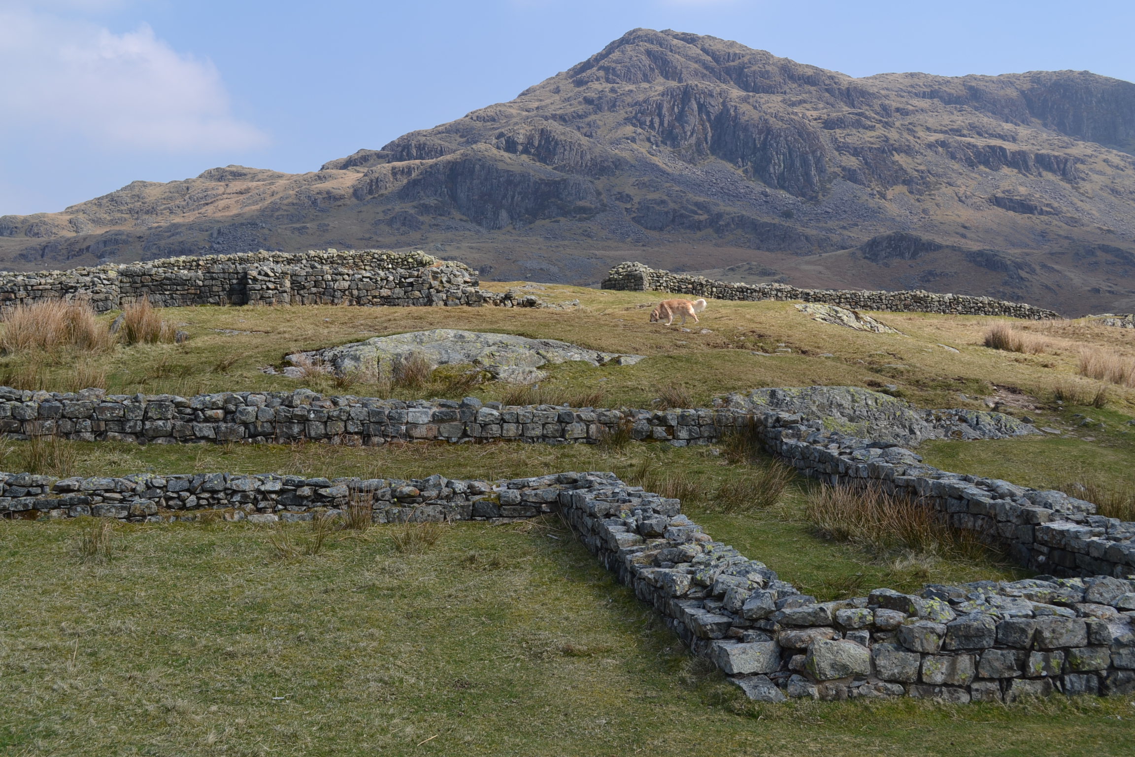
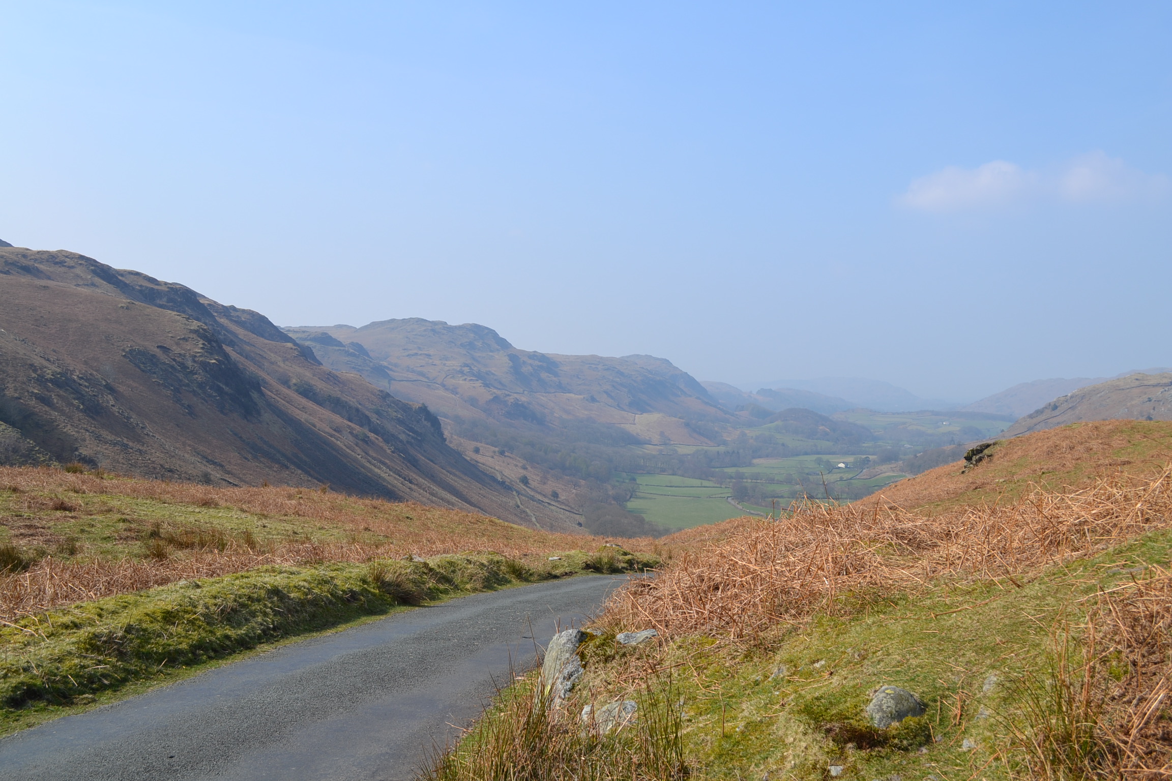
High in the mountain passes of the Lake District in northwest England, some distance from Cambridgeshire, lies a long ruined Roman fortress that once guarded the northern borders of the Roman Empire. It is hard to imagine a time when the beauty and tranquillity of Cumbria, now so often visited by hikers and outdoor enthusiasts, was a battlefield. In the early Second Century, during the reign of Emperor Hadrian, the Mediobogdum Fort was constructed along a chain of fortifications to prevent an invasion of Roman Britain (we are reasonably sure that Mediobogdum is now identified as the Hardknott Roman Fort). It was built along the mountain pass that left the port of Glannoventa (modern day Ravenglass) in the Eskdale Valley and crossed the hardknott mountain towards Windermere. Nowadays, the single-track road is notorious as the steepest and most treacherous mountain track in all of Great Britain, loved by motoring enthusiasts. One can imagine at the difficulty of garrisoning, supplying and constructing a military encampment high in the mountains of the Lake District – what is even difficult to access by auto today.
This fort, built and occupied before Hadrian’s Wall was constructed several miles to the North, was at its time the last outpost of Empire – almost a thousand miles from the Imperial City of Rome. The remoteness of this posting would have been breath-taking for the 500 men and officers garrisoned here – who we know from extant Roman records were the Fourth Cohort of Dalmatians. These men were raised on the balmy eastern shores of the Adriatic Sea (present day Slovenia, Croatia, Montenegro, and Albania). They would have travelled overland across Europe and then sailed to western England to reach this hostile borderland, where conflict with Picts and other tribes from present day Scotland was a constant threat.
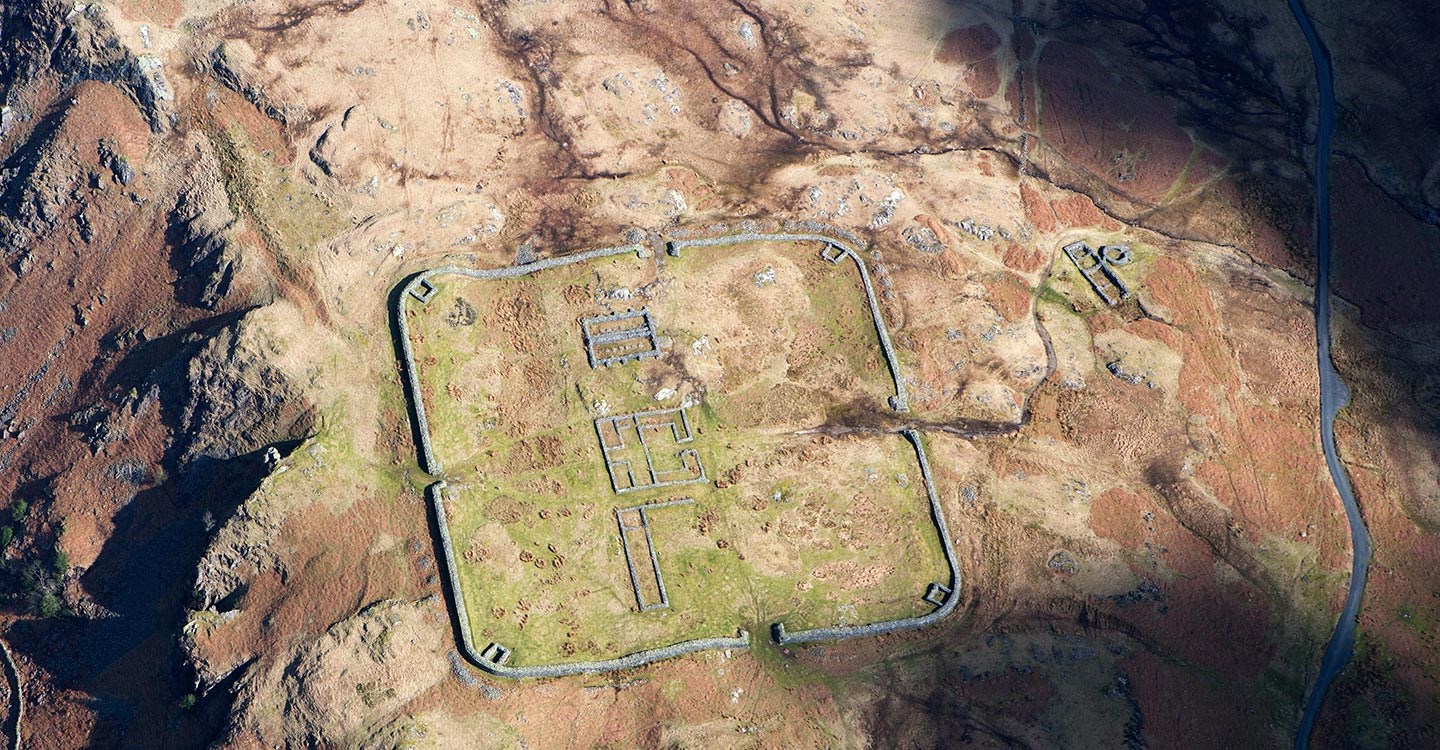
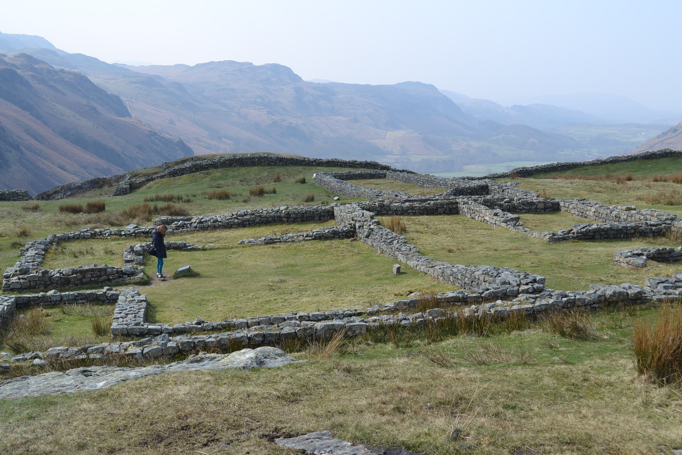
Laid out with military precision, it is still easy to walk the perfect square of Hardknott Fort, 110 meters per wall, with four gates and corner towers. The road of the day would have entered the fort via one gate and led travellers, merchants, and local peasants out through the opposite, ensuring the soldiers could maintain control of the key mountainous terrain, the movement of people and goods, and the levying of customs taxes. One nowadays can walk through the foundations of the Commanding Officer’s Praetorium, or villa. You can easily picture the wooden supports that would have comprised the barracks for the soldiers, junior officers, and auxiliaries, and think on the remoteness of this post. The foundations of the headquarters building, the granaries, and the forementioned Praetorium occupy the central ground of the fort. Just outside the northern gate is a parade field, a testament to the Roman Empire’s renowned discipline of its troops. A bit farther afield the ruins of a bath house remain, a reminder that not all of life in Mediobogdum would have been austere and grim.
Today, Hardknott Fort is jointly preserved by both English Heritage and the National Trust. Not easily accessible, you must navigate the Hardknott Pass and then hike to the Fort, which is perched on the middle slopes of the Hardknott peak. Visit: http://www.english-heritage.org.uk/visit/places/hardknott-roman-fort/ for more information on the fort.
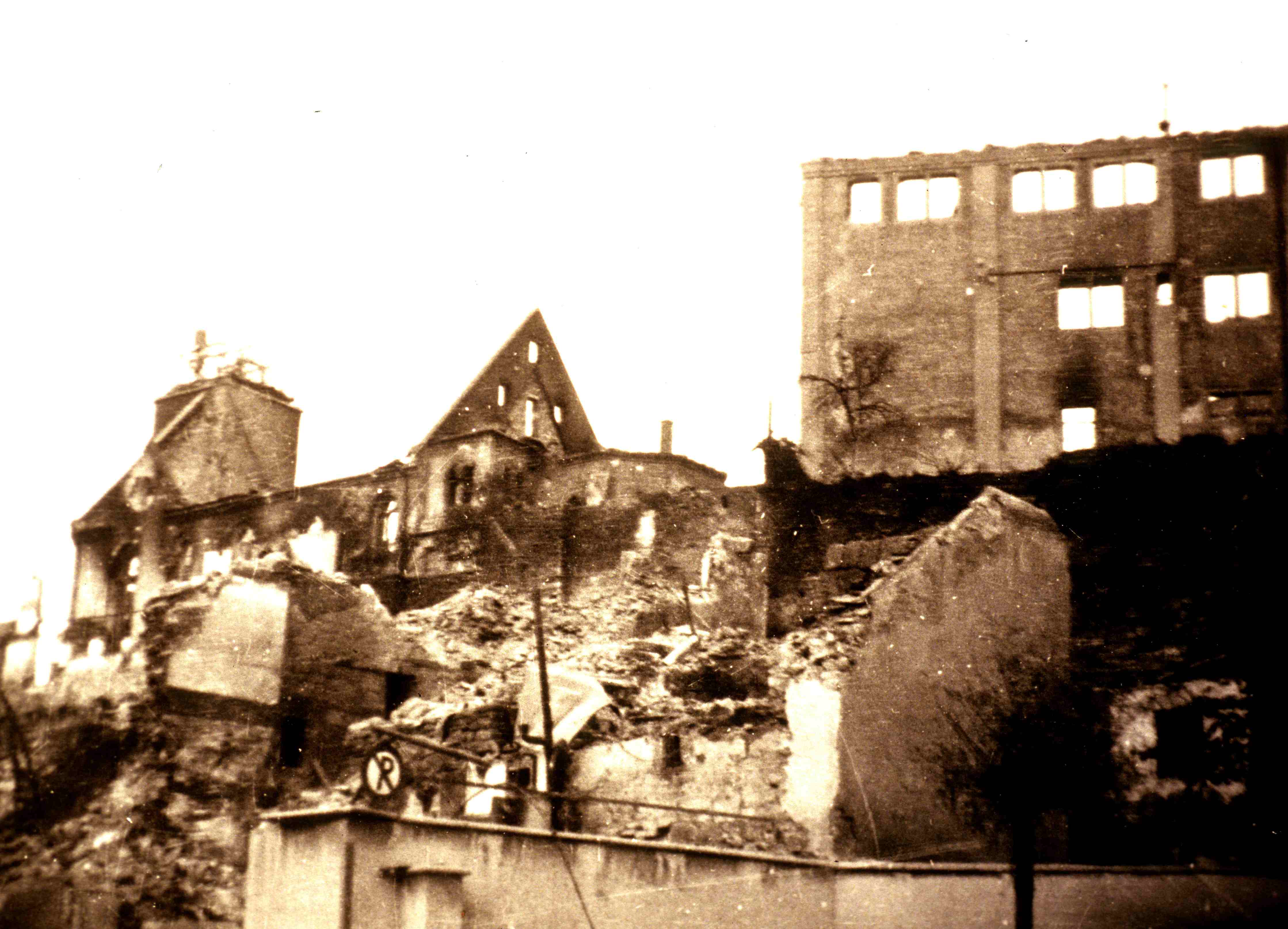
I often write in this dialogue with you about the local history of Cambridgeshire, and frequently about the efforts during the Second World War which originated from the bases and airfields spread throughout southeast England. However, this week I find myself in the small town of Böblingen, Baden-Wurttemberg, in southwest Germany. It is an ancient town which was accidentally bombed during the war, bombed and destroyed. Here one sees the horrific reality of what 8th Air Force and Bomber Command’s strategic bombing wrought on the ground. The level of destruction waves of heavy bombers were capable of achieving in an effort to destroy Germany’s military might is sobering. This small town is but one example of millions of lives that were horrifically changed by the Second World War – and is not a judgment on guilt or innocence – but is simply what happened.
“Böblingen 01 1939-07-01” by Ansgar Walk – Foto erstellt von Ansgar Walk. The town on 1 July 1939.
On the night of 7 October 1943, 343 Avro Lancaster Bombers, launching from airfields in Cambridgeshire and beyond, formed up and began a major night raid on the military-industrial targets of Stuttgart. It was overcast and dark, some of the aircraft from the 101st squadron were equipped with night-fighter jamming equipment (this was “CIGAR” first operational use in a combat mission). This allowed the bombers to conduct the raid with little resistance. A diversionary raid on Munich further confused the German fighters and the bombers reached their targets relatively unhindered and dropped waves of ordnance, explosives followed by incendiary bombs, losing only four aircraft that night. The mission was hailed as a success – for the industrial capacity of Stuttgart needed to be destroyed to slow the German war machine.
Things were very different in the sleepy town of Böblingen, 10 miles southwest of Stuttgart, where no military targets were located. By mistake, one of the two pathfinders which dropped aerial markers to guide in the remaining bombers, marked Böblingen instead of the industrial facilities of Stuttgart. Following the pathfinder’s lead, the Lancasters dropped 35 high-explosive bombs before over 400 incendiary bombs over the unsuspecting town. The Schloβberg, church, and over 70% of the old town was destroyed. 1,735 people lost their homes, and most tragically, 44 people died including 24 women and children. As I walked around the Schloβberg this week, which still is the central part of the rebuilt town, I found small intact pieces of the medieval castle which survived the night. One can still see the black scorching on the medieval stones, which were burned permanently into the rock by the inferno caused by the incendiaries. It isn’t hard to picture the horror of that night to the people of this small town, rushing about, seeking shelter and tending to the destruction.
“Zentrum von Böblingen nach dem Bombenangriff vom 7./8. Oktober 1943.” Date 12 October 1943 Source Foto erstellt von Ansgar Walk. Photograph by Ansgar Walk . The shell of the nave of the protestant church can be seen in the centre of the photo, where the remembrance memorial now stands.
On the back of the rebuilt protestant church, which was just a shell of stone after the night’s bombing, I found a small stone marker that commemorates the loss of that night – a phoenix flies up from the ashes – and the inscription reads: “Destroyed by bombs during the night of 7/8 October 1943, rebuilt 1949/1950 for the glory of God.”
Sadly, another very similar event happened in 1944, when Böblingen was once again struck out of confusion by bombers seeking the heavy industry of Stuttgart. More deaths, more destruction in this small town so desperately affected by the Second World War.
A check of the Statistisches Bundesamt, the Federal German Records Office, shows that in the last census before the war, Böblingen had a population in 1939 of 12,560. In 1946, 10,809 people were counted in the town. 1,751 people had disappeared from the town. Behind those numbers are enormous tragedies: lost civilians in the raids yes, but also lost soldiers, dispossessed families that left never to return, and even those murdered by the regime. Time has passed now and I don’t seek to judge or to search for any more horror here. A tragedy has woven together with accidental targeting of an unimportant town, spurred by the deliberate bombing of military-industrial targets, the civilian losses, the impact of the war on these people, but also the crews of the four Lancasters which were lost that night, and the overall efforts of so many for so long during a dreadful time. The greater tragedy of the Second World War can best be found in seeking the personal stories, the human struggles of so many in the face of such horror over so long.
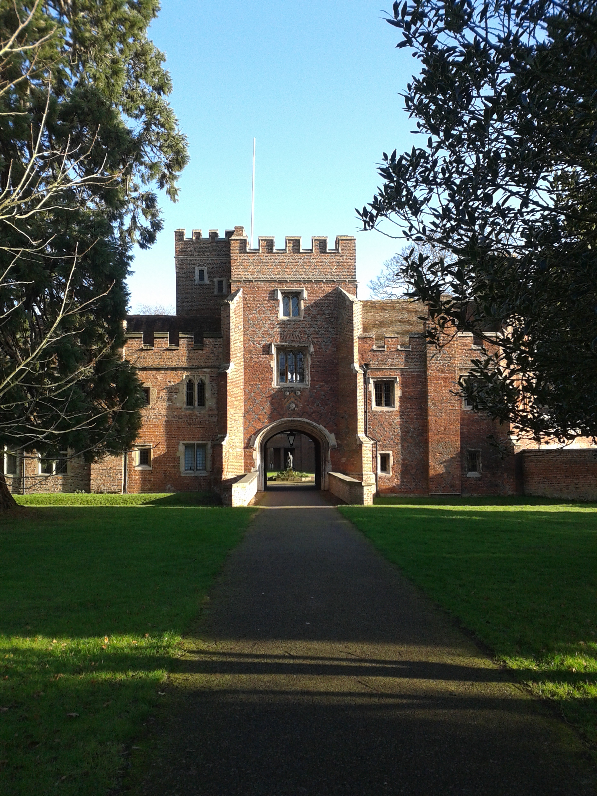
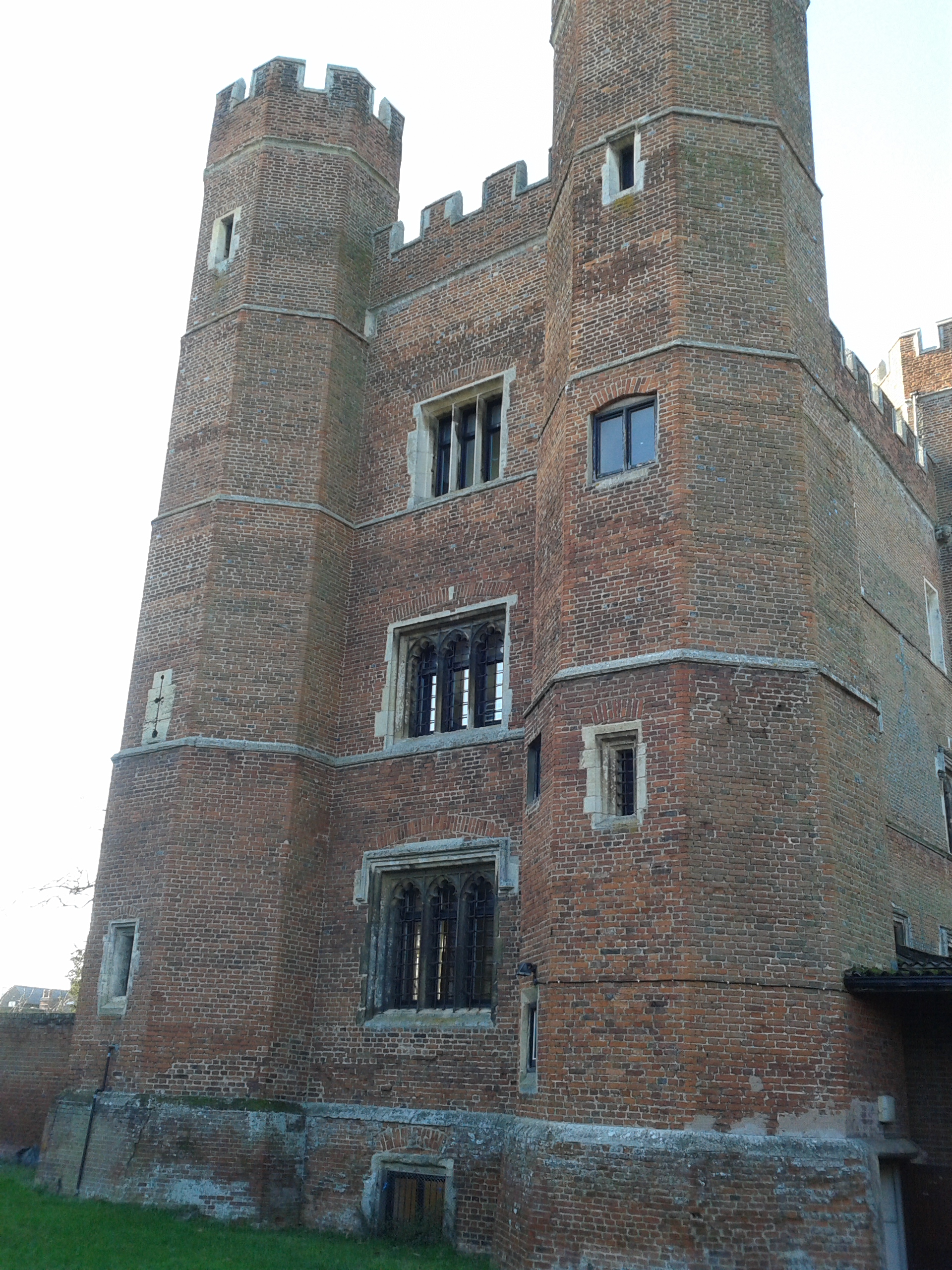
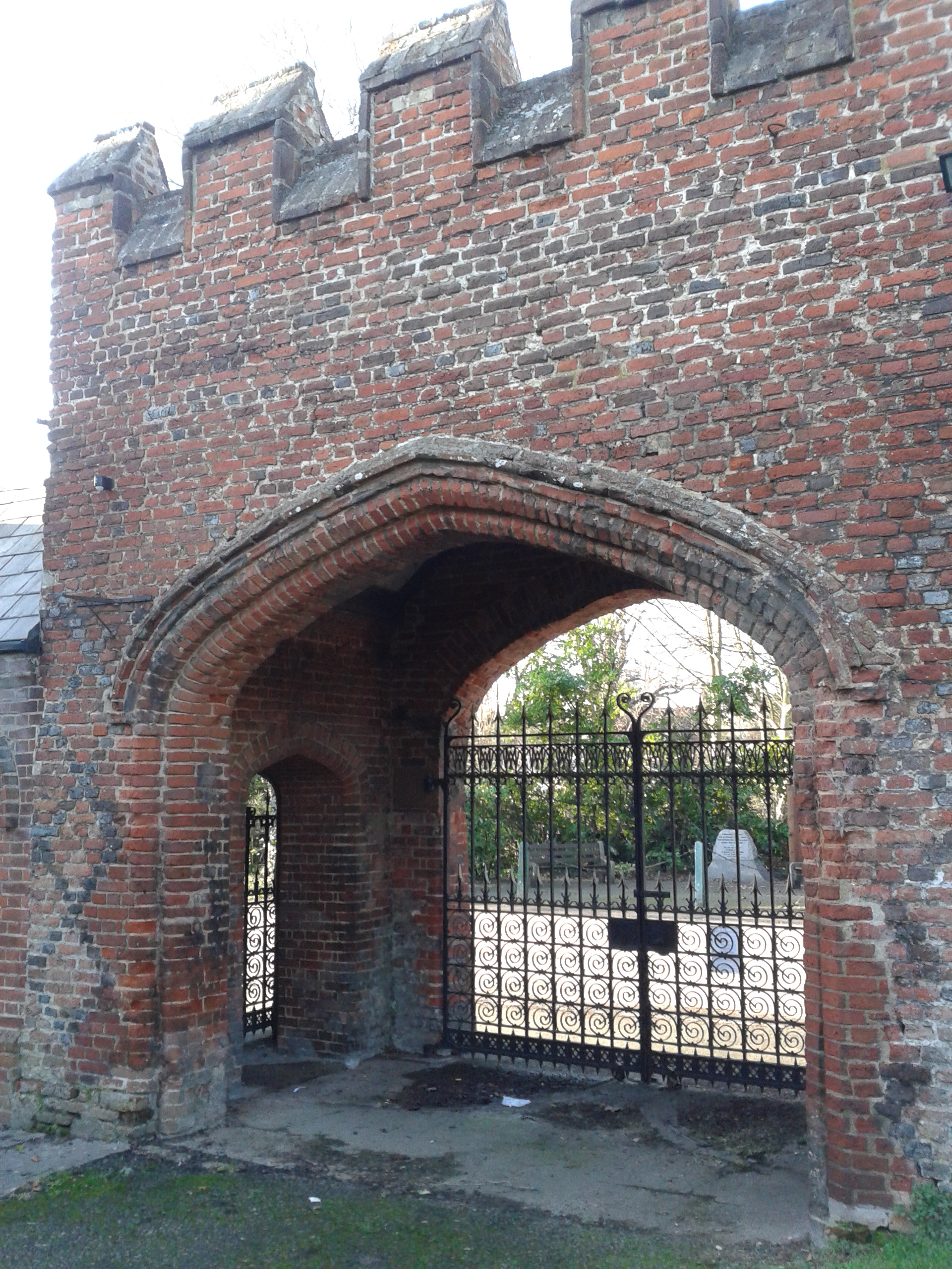
Along the Great North Road, traveling from London through Cambridgeshire is the small, peaceful village of Buckden. Old coaching inns now have been turned into gastro-pubs, while the picturesque houses are smartly refurbished and often owned by those who make the long commute into London by train – the lost time more than worth living in the beautiful Cambridgeshire countryside. In the centre of Buckden, however, an ancient fortified manor house built in the 15th Century rises over the thatched and tiled roofs of the village, the bricks and stone having replaced the wooden 12th Century Bishop’s Palace which has long since disappeared. It was here that Katharine of Aragon was imprisoned and the Bishops of Lincoln lived, surrounded by crenulated walls, moat, and outer bailey. It speaks of an age when a bishop was a wealthy feudal lord, who led the diocese but also maintained an army.
The brick towers of the fortified manor house were added in 1475, during the War of the Roses by the Bishops of Lincoln. It is during that period of conflict that the Bishop’s Palace appeared to reach the height of its defensive works – fortified manor with towers, crenulated interior wall, moat, and outer bailey. Sadly much of the defensive works were demolished during the Commonwealth in the 17th Century and in the 19th Century, but that cleared the way for some impressive later Victorian era buildings. The Bishops of Lincoln left the property in 1837. The moat was filled in 1871 as the Victorian buildings were finished and the Palace serves as a religious retreat to this day. The Claretian Missionaries now reside here, but the grounds are open for one to wander around and appreciate this ancient fortified manor house.
Many monarchs were entertained in the Bishop of Lincoln’s Palace at Buckden: Henry III stayed here in 1248, Edward I called the Longshanks and Malleus Scotorum was here for a time in 1291. Richard III visited the Palace in 1483, the first year of his short reign that would end two years later at Bosworth Field.
The Palace of Buckden is probably best known for holding Henry VIII’s first Queen, Katherine of Aragon during the King’s Great Matter, from July 1533 until May 1534 until she was transferred a few miles away to Kimbolton Castle, where she died in 1536. She would eventually be buried just north of both Buckden and Kimbolton at Peterborough Cathedral.
Miniature of Catherine Howard as Queen of England by Hans Holbein the Younger. This image is in the public domain.
Ironically, a few years after her death, an aging Henry VIII would stay at Buckden Palace with his fifth wife, Catherine Howard (she was 17 at their marriage; Henry was a gouty and obese 50). They stayed at the Palace in 1541, during a summer tour that the King and Queen took of England before her coronation. It was during this tour that Catherine would be accused of committing adultery with Thomas Culpeper which led to her beheading for treason in 1542. It is unknown what occurred between Henry and his penultimate wife while at Buckden Palace, but the fortified manor certainly served as a major setting for the drama of Henry’s love affairs – which ended so tragically for the two women who stayed at Buckden.
Buckden has a helpful website with a well-written and informative section on the history of the village where the palace plays a central role: http://www.buckden-village.co.uk/history/
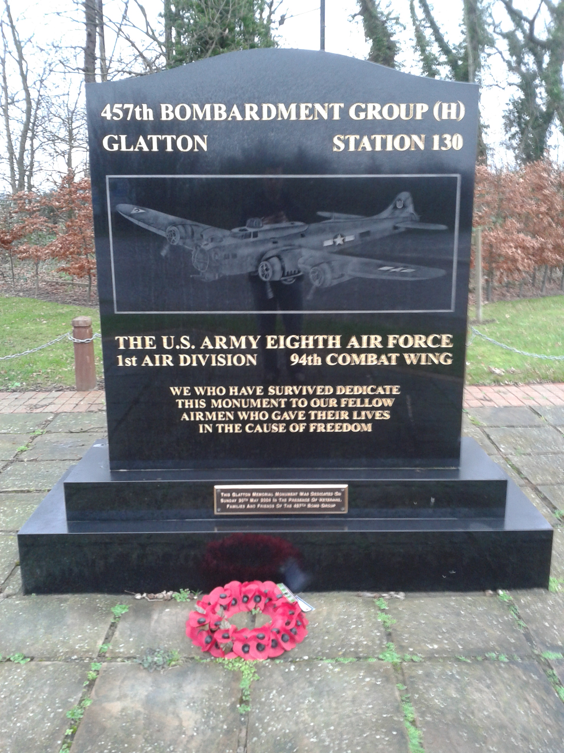
Between Huntingdon and Peterborough, in the west of Cambridgeshire lies the small village of Conington. With its beautiful All Saints Church, first mentioned in Domesday Book and rebuilt in the early 16th Century, and remarkably beautiful cottages and homes perched on the edge of the fens, one can hardly imagine that 70 years ago this was the home of four squadrons of B-17 Flying Fortresses, roaring into the air almost daily for targets in Germany and Occupied Europe.
The Control Tower, now demolished, of RAF Glatton, taken on 31 March 1945. In the distance, to the left of the tower, a B-17 is visible on the taxiway. US Air Force Photograph, in the public domain.
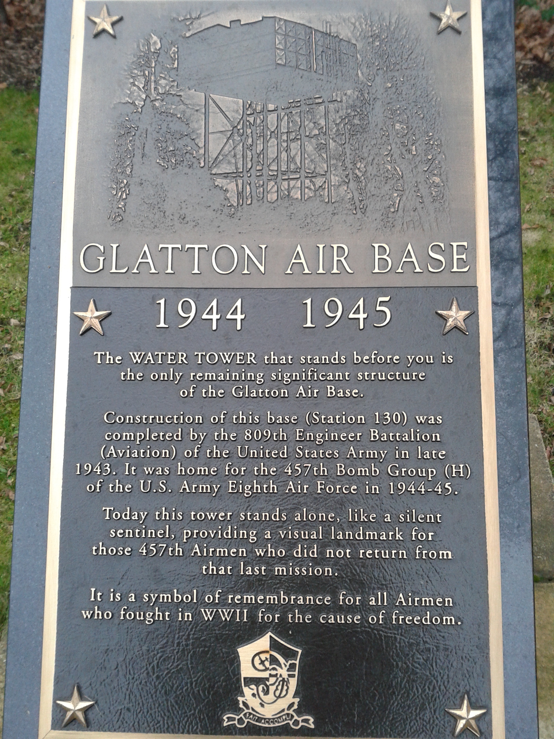
In the Second World War, Conington was located next to Royal Air Force Station Glatton, which was constructed to Class “A” standards by engineers to support heavy bombers in 1943 with the intent of being used by the U.S. Army Air Forces in the strategic bombing campaign. The 457th Bombardment Group (Heavy) arrived on 21 January 1944, consisting of the 748th, 749th, 750th and 751st Bombardment Squadrons. The recognizable tail code of the 457th was the “triangle U” painted on the vertical stabilizers of the Boeing B-17 Flying Fortresses which operated from the air base. The 457th Bomb Group operated RAF Glatton from January 1944 until 20 April 1945, when it completed its 237th and last combat mission at the conclusion of the war.
Before June 1944, the 457th operated on attacking strategic targets in Germany – munitions factories, ball-bearing plants, marshalling yards and oil refineries. On D-Day, the 457th flew missions against Cherbourg Peninsula, attacking German positions off the east flank of American forces landing at Utah and Omaha beaches. By July 1944, the 457th had resumed strategic bombing and would continue to focus on German targets through April 1945. However, the 457th provided aerial bombing support to the breakout from St. Lo in northern France, the British 1st Airborne’s landings at Arnhem in the Netherlands, and in support of embattled U.S. Army forces in the Battle of the Bulge.
At the conclusion of the War, the B-17s of the 457th Bomb Group returned to the United States and the airfield was used by No. 3 Group of the RAF Bomber Command flying B-24 Liberators and Avro Lancaster heavy bombers. By 1948, it was decided that the airfield was surplus and the land was returned to agricultural use and demilitarized.
Today, one of the Class A runways remains in use as the “Peterborough Business Airport” which is a general aviation facility. It is a testament to the strength of the runways built over 70 years ago that the field remains in limited and lighter use. The only other structure from the Second World War is the water tower which stands near the 457th Bomb Group Memorial, off Great Ermine Street, near the village. In All Saints’ Church, Conington, is a memorial to the 457th Bomb Group which must be visited.
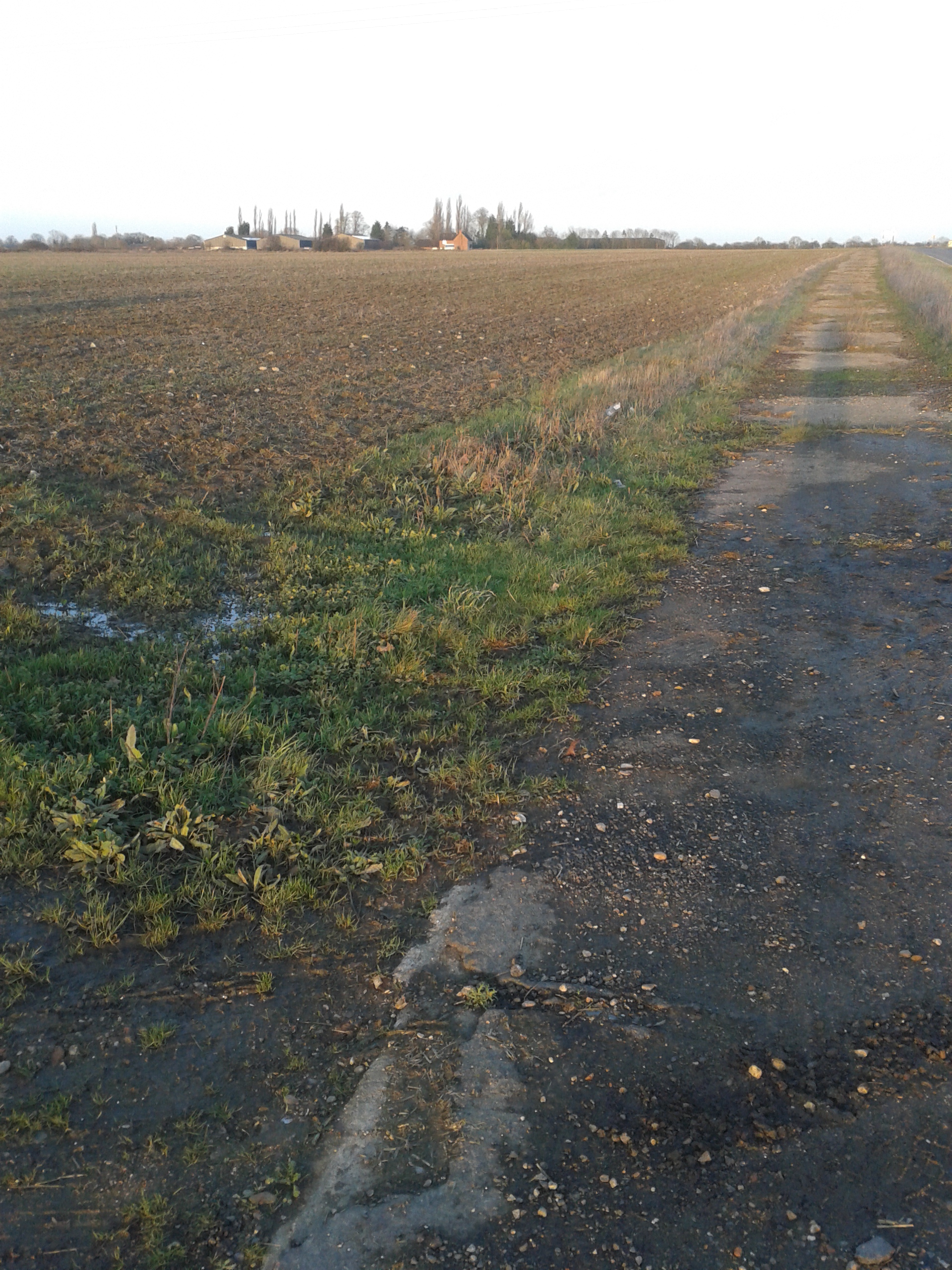
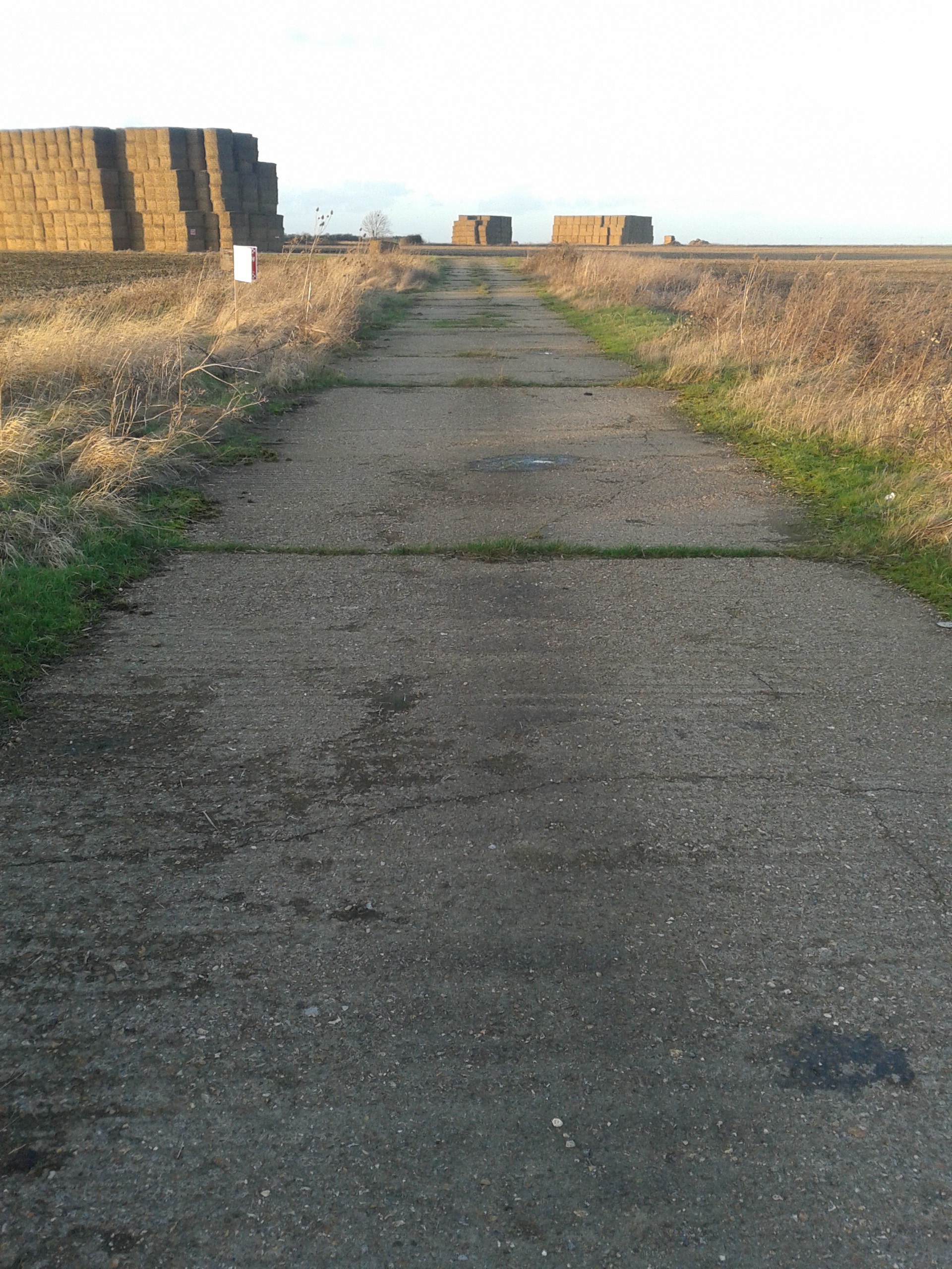
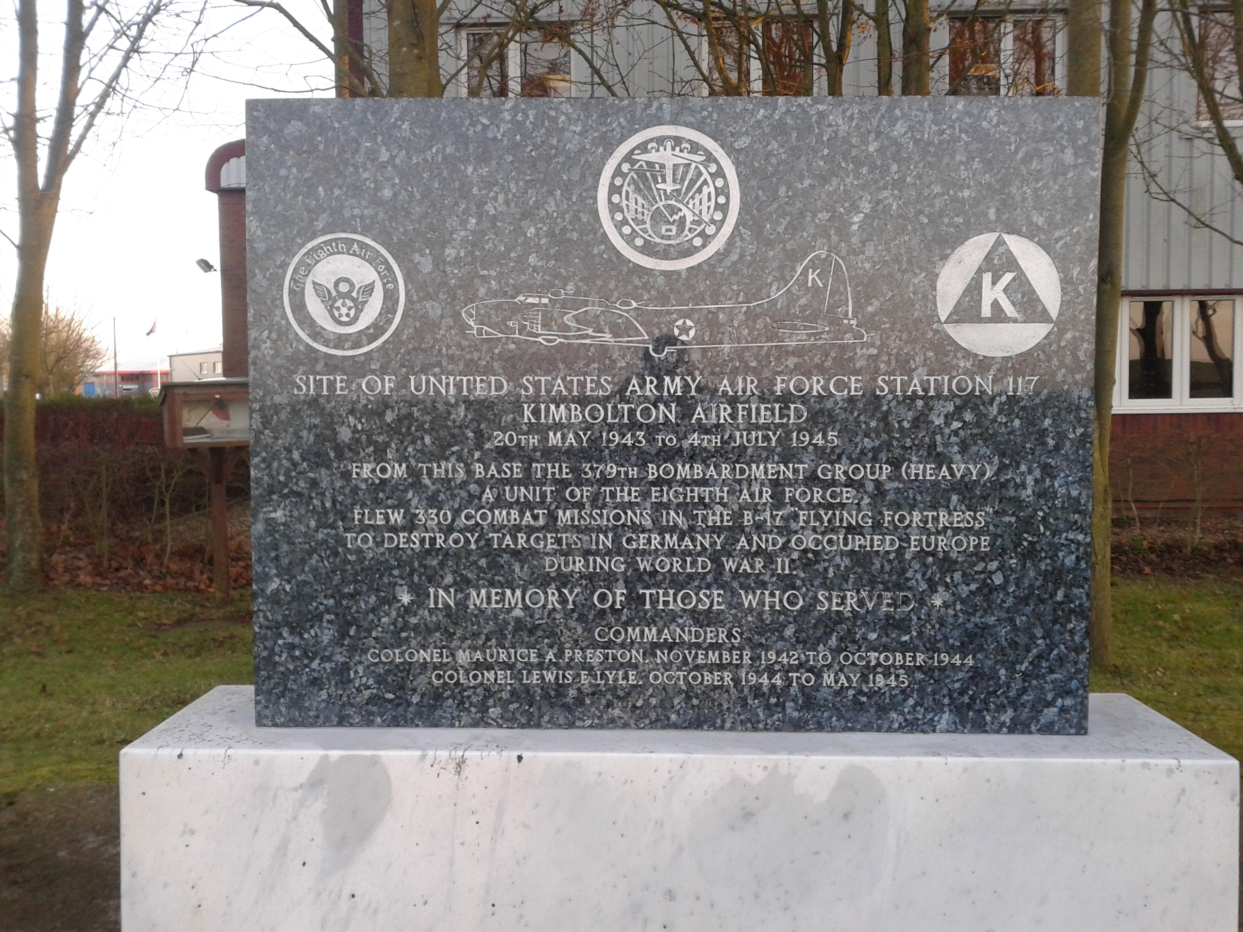
A few miles west of Huntingdon, Cambridgeshire, between the villages of Stow Longa and Kimbolton, rests a flat, windswept area of farmland that the B-road snakes across. One can easily miss the short stretch of narrow road that cuts across the older, crumbling concrete of class-A taxiways that once carried B-17 Flying Fortresses to the main northwest-southeast runway. If you stop and trudge out across the muddy public footpath which heads due west, you will come across patches of concrete, often covered in hay bales for the local livestock. It is an eerie scene, for one cannot help but picture the heavy bombers combing back from a mission deep over Germany, and in the strong winds that blow across the flat fields, one can almost hear the engines of the bombers.
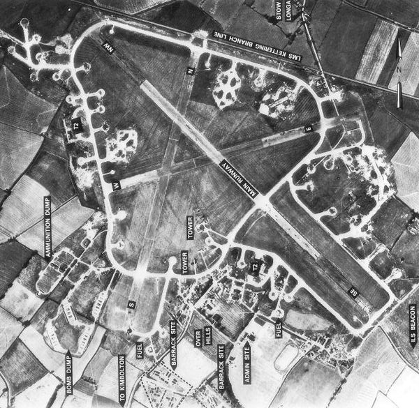
These flat fields with their small patches of runway and tarmac are all that remain of Royal Air Force Station Kimbolton, a Class A airfield used by the U.S. Army Air Forces’ Eighth Air Force from 1942 through the end of the Second World War. First the 91st Bomb Group (Heavy) arrived in 1942 and began operations from RAF Kimbolton but had to move off the field quickly as the runways were determined neither strong nor long enough for the heavy bomb loads the B-17s carried. Until the runways could be improved, the 17th Bomb Group (Medium) used the field, flying the Martin B-26 Marauder, from October of 1942 until the group departed for North Africa. With 17th Bomb Group’s departure, the main runway was strengthened and extended, as is visible in this aerial photo of the base taken on 10 August 1945 shows:
RAF Kimbolton on 10 August 1945. The village of Stow Longa is just visible on the top of the aerial photograph. The village of Kimbolton is to the south. This artistic work created by the United Kingdom Government is in the public domain.
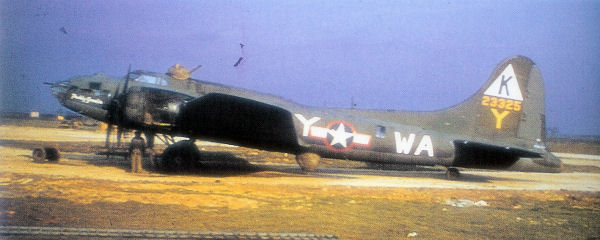
Then came the 379th Bomb Group (Heavy), with its famous “triangle-K” markings on the vertical stabilizers of the B-17s, which would operate from RAF Kimbolton until the end of the war. Four squadrons: the 524th, 525th, 526th and 527th Bombardment Squadrons comprised the 379th which flew its first combat mission on 19 May 1943. Focused on the war-making capabilities of Germany, the 379th flew raids on heavy industry, refineries, warehouses, submarine pens, airfields, marshalling yards and command and control centres across occupied Europe. They flew bombing missions against the ball-bearing plants at Schweinfurt and Leipzig, against synthetic oil plants at Merseburg and Gelsenkirchen, against the chemical plants at Ludwigshaven and airfields from Occupied France to Berlin.
A B-17F belly landed at RAF Kimbolton. An amazing testament to the rugged airframe, this B-17 was repaired and returned to a flying status. U.S. National Archives, This image or file is a work of a U.S. Air Force Airman or employee, taken or made as part of that person’s official duties. As a work of the U.S. federal government, the image or file is in the public domain.
On 11 January 1944, the 379th attacked aircraft factories deep in Germany without fighter cover, earning the unit the coveted Distinguished Unit Citation. Before D-Day, the group focused on strong fixed positions, rail transfer and choke points, and gun batteries: softening up the Atlantic Wall before the greatest amphibious invasion in history.
B-17F at RAF Kimbolton. Note the “Triangle K” tail marking. U.S. National Archives; this image or file is a work of a U.S. Air Force Airman or employee, taken or made as part of that person’s official duties. As a work of the U.S. federal government, the image or file is in the public domain.
The B-17G Serial # 42-32024, named the “Swamp Fire” famously flew 100 missions without a single abort – an unheard of accomplishment during the war from RAF Kimbolton. Forty different crews took the plane on her missions over occupied Europe and Germany. According to the Swamp Fire website, where veterans who flew on her during the war post memories and photos, a joke around the base in October 1944 was that: “After a new nose and tail section, a new ball turret, 16 engine changes, three wing replacements and over 1,000 bullet and flak hole patches, there is not much of the original plane left.” However, in a ceremony for the aircraft after her 100th mission, the Commanding Officer of the 379th, Colonel Lewis Lyle said: “No, there isn’t much of the original Swamp Fire, just the fighting spirit and tradition built into her and maintained by her ground and combat crewmen. She is an excellent criterion of the greatest bomber in the European Theatre of Operations.”
B-17 Serial #42-32024 “Swamp Fire”. This is a picture of the mission crew who flew on her 25th mission on 4 May 1945 (note 24 bombs painted on her side for completed missions). Standing, left to right: TSGT Edward J. Przybyla radio operator, 2LT Harvey “Herk” Harris bombardier, SSGT Roy E. Avery, Jr. waist gunner, 1LT Joseph L. Korstjens pilot, SSGT Andrew Stroman, Jr. ball turret, SSGT Berj G. Bejian engineer, SSGT John K. Rose waist gunner, 2LT Matthew J. Scianameo navigator, SSGT Elijah W. Lewis tail gunner, 2LT Byron B. Clark co-pilot. The dog is “Lt Scragg” swamp fire’s mascot. Kneeling left to right is the ground crew: Rube Cohn, Seymour Romoff, James Abbott, Henry Gerhart and Dominick DeSalvo. Thanks to the Swamp Fire website for this image.
The 379th Bomb Group holds the record for the most tonnage dropped of any U.S. Army Air Force Bomb Group operating from the United Kingdom – 26,459 tons of ordnance. The 379th holds the record for most missions flown: 330 between May 1943 and May 1945. In June 1945, the 379th transferred from RAF Kimbolton and the base was closed temporarily. From the late 1940s until the early 1960s, the Royal Air Force used the base for basic training of new recruits before it was finally closed, dismantled and returned to agricultural use.